Showing posts with label Shipwrecks. Show all posts

Friday, 26 June 2026

The Wreck of the Cutter Oi on Panepane Beach, 1890


Panepane Point and Beach from Mount Maunganui, showing part of the narrow main shipping channel and the Tauranga harbour.

Populated for centuries by Māori iwi, and today mostly associated with Ngāi te Rangi hapū, Matakana Island is a long, flat barrier island 20km in length and about 3km wide. The island forms a sand barrier between Tauranga Harbour and the vast South Pacific Ocean. Since time immemorial Matakana’s dune-backed beach has been a landing and wrecking site for waka Māori, and before and following the Treaty of Waitangi in 1840, a diverse range of Māori and Pākehā owned sailing vessels.

The name Panepane in 19th century European sources referred to a specific southern section of Matakana Island close to Panepane Purakau or Panepane Point, not the entire ocean beach [1]. It was in fact a name for the southernmost three kilometres located across the channel from Mauao | Mount Maunganui.

Sailing craft, driven eastward during gales, were thrown bodily onto the beach where their crews attempted to leap clear into the surf, before their vessels began a deadly mast-shattering roll. Again, when sailing vessels of all sizes attempting to enter or leave the harbour during marginal conditions missed the channel by even a little, they, depending on conditions, either grounded temporarily or were rolled and wrecked among the breakers.

A Tauranga-owned and -based cutter, the Oi became a common sight on Tauranga Moana during its three-year working career - likely named, in part, after the common nautical haloo in use at the time, “Oi, ahoy!” Kauri-built cutters were much favoured by Tauranga’s small maritime entrepreneurs though they never outnumbered schooners. Interestingly, their single owner-operators also styled themselves master mariners though their crews might number only one or two.

On 16 January 1890, the Oi left the little Bay of Plenty port of Maketū. Crossing the Kaituna River outlet through heavy surf, it began the short 27km (14.6 nautical sea mile) voyage up the coast to Tauranga with a cargo of flax. Information on the cutter’s tonnage is not available, probably because it was unregistered. Regardless, the provisions and coastal timber trade on the Coromandel and Bay of Plenty coasts between the 1870s and 90’s was often handled by sailing cutters of 8-30 tons.

A gale had sprung up a day before the Oi’s departure from Maketū, but the captain and crew, later identified as ‘Messrs W. Turner and W. Cinnamon’ undertook the voyage regardless. The Oi cutter was last seen on the same day by people near Mount Maunganui around midday. It was then battling heavy seas just off Motuotau | Rabbit Island and Moturiki | Leisure Island and heading towards the Tauranga Harbour entrance [2].

 There were soon grave fears at Tauranga for the safety of the Oi and its crew, and two days later, despite the gale which was to last for a week, an intrepid search party comprising ‘Messrs Moss, C. Faulkner, C. Spencer, Allely, Maxwell, and Cotter’, was organised. First crossing by boat to Pilot Bay below the Mount, they were informed by the crew of another cutter that had just safely passed through the Mount Maunganui Channel, that they had seen wreckage of another vessel on Matakana Island’s Panepane beach.


The old Auckland-based, gaff-rigged cutter Jesse Logan. Note the long bowsprit which, without making their masts taller, increased the sail area of cutters while allowing the sail plan to be broken down into smaller, more manageable headsails.

Crossing the channel to Matakana Island and Panepane Beach, the search party found the remains of the Oi lying literally smashed to pieces above the high-water mark.

The mast was broken off to a stump, the bowsprit was completely wrenched out, and the timbers had all parted at the stern, leaving a great gap. Her hatches were off, and the hold was swept of everything. Her rudder was found broken in two places, and her sails were found on the beach double reefed. No trace of the crew was discovered, and there is little doubt that these unfortunate young men have found a watery grave. It is difficult to say what caused the catastrophe [3].

The following day, the same party began another search along the full length of Matakana Island’s ocean beach on horses hired from the Island’s Māori residents. Half way towards Tauranga Harbour’s northern Katikati entrance ‘they found broken oars, part of a hat belonging to Cinnamon, and parts of an accordion’[4].  Footprints on the beach initially gave some hope and the cutter Eleanor and several other local boats continued the search as the gale abated. The police also searched Mount Maunganui’s forested slopes but the Oi’s crew were never found [5].

 The loss of well-captained, shallow-draught, local vessels like the Oi had disruptive as well as tragic outcomes for the Bay of Plenty’s coastal communities. From December 1887, for instance, the Oi had transported much needed cargoes of provisions and sundries twice per month from Tauranga to the settlements of Katikati and Te Puke on the Uretara and Kaituna Rivers respectively, ‘cash on delivery’. In one instance, the cutter had sailed the inner harbour route from Tauranga to deliver, to the Uretara River bridge at Katikati, sacks of potatoes, flour, sugar, oatmeal, seed, ‘maize by the bushel’, and boxes of tea, soap, candles, jam and golden syrup for the new settlers there [6]. 


A beach-wrecked ketch or sloop at the high-water mark.

The Oi was by no means the last Pākehā or Māori owned sailing craft to be wrecked or temporarily stranded in the wrecking zone on Panepane Beach. In May 1893, just three years after the Oi’s loss, the wreckage of an unidentified ketch was found on Panepane Beach following a gale. The violence of the wrecking had broken off the 25-foot mast at deck level. Again, the bodies of the crew were never found [7].


References

[1] Panepane Purakau, Western Bay of Plenty District Council,https://www.westernbay.govt.nz ›community› projects

[2] Te Aroha News, 23 April 1890: 4.

[3] Ibid.

[4] Ibid.

[5] Ibid.

[6] Bay of Plenty Times, 9 December 1887: 3.

[7] Grey River Argus, 9 May 1893: 2.

Image credits

Panepane Point, Matakana Island, photo/file. Kiri Gillespie, ‘Matakana Island proposal: Panepane Point plan prompts encouraging level of interest’. Bay of Plenty Times, 27 August 2020.

 Jessie Logan, circa. 1880s. Restoration of NZ’s Oldest Surviving Yacht’. Image courtesy of Keith Pine, New Zealand Prosthetic Eye Service, info@prosthetic eye service.

 Abandoned maritime wreckage. Stocktake royalty free images https://www.freepik.com › free-photos-vectors  


Friday, 15 November 2024

The Wreck of the SS Manaia, 1926

Whakahau-Slipper Island lies two miles off the Coromandel Coast, four miles south-east of Tairua and some 100 miles from Auckland.

While carrying passengers and cargo during its regular Tauranga to Auckland run, the SS Manaia (Captain W. F. Norbury), ran aground on the southeastern point of Slipper Island on the night of Thursday 10 June 1926. Reefs in the vicinity had previously claimed The Northern Steamship Company’s auxiliary schooner Te Teko and the timber scow Surprise.

The SS Manaia aground near Slipper Island

Built at Dumbarton, Scotland in 1898, the Manaia was a well-known New Zealand coastal steamer of 1,159 tons. Formerly owned by the Union Steam Ship Company and named Rotoiti, it was bought and renamed by the Northern Steamship Company for its Auckland to Tauranga service. The steamer’s dimensions were: length, 220 feet; breadth, 33 feet and depth, 13 feet.

Steaming northwards through rain and mist, the Manaia struck at 11.30 p.m. with an impact described as ‘terrific’. Members of the crew were thrown from their bunks, there was some ‘mild panic’ among the passengers, but there were no injuries nor deaths during the subsequent rescue operation.

Whakahau-Slipper Island
Courtesy of New Zealand Herald, 16 April 2015

Observing the wreck at daylight from the coastal settlement of Tairua, eyewitnesses described the steamer as ‘about one mile off Slipper Island, well up on the reef behind a small rocky island’, and ‘broadside on and down in the stern, in a very exposed position’.

Carrying 55 passengers who had boarded at Tauranga’s Town Wharf at 8 p.m. the Manaia’s cargo was indicative of regions exports during the 1920s: 63 cases of fruit, 21 sacks of maize, 34 bales of flax, 21 bales of tow, 34 bales of sheepskins, four cases of bacon, a quantity of general cargo and a ‘fair-sized’ consignment of mail.

At 11.40 p.m. the Auckland Radio Station received signals from the Manaia’s radio operator, that it was ashore near Slipper Island, and was being held in place by her propellers. Captain Norbury advised that he was all right until morning, before later, asking for assistance when the weather became squally, and the Manaia began to bump heavily.

At 3 a.m. the Auckland authorities radioed the SS Ngapuhi, another Northern Company ship which was passing Kawau Island, on its way from Whangarei to Auckland. The Ngapuhi changed course and after steaming 70 miles in six hours, was standing near the Manaia, which was then ‘making water fairly fast’, through a hole in the bow.

The SS Ngapuhi
Auckland Libraries Heritage Collections JTD-19M-04168

A two masted timber scow and the Corey-Wright brothers launch Ellida from Tairua, were also soon on the scene, and at 9 a.m. the SS Rimu was dispatched from Auckland to provide additional assistance.

Captain Dorling kept the Ngapuhi’s lead line going, as he negotiated the foul ground and a line of sunken reefs between his ship and the stricken steamer. He noted that the Manaia was hard and fast on a reef extending out from the southeast point of Slipper Island, with the bow high on the rocks, her stern riding low in the deep water surrounding the reef.

During the rescue of the passengers, the seas were moderate and the weather clearing. A message at 10.22 from the Manaia, announced that the Ngapuhi had arrived and was taking the passengers off, and that two lifeboats had got away safely. A wireless message at noon stated that all passengers had been transferred to the Ngapuhi which reached Auckland shortly before 11p.m.

At Auckland, the male passengers praised the conduct of the women and children, as well as Captain Norbury and his officers - particularly the children, who were said to have ‘just stood by without a murmur.’

During salvage operations, which began after the Manaia had been written off by the Northern Company, all portable equipment and fixtures were removed, along with machine fittings. The only cargo not put aboard the Motu, one of the salvage vessels, was a few cases of fruit in the fore hold. When the Manaia’s stokehold and engine-room flooded, the crew of 36 left the wreck on the Motu. The SS Manaia gradually slipped off the reef and into deep water.

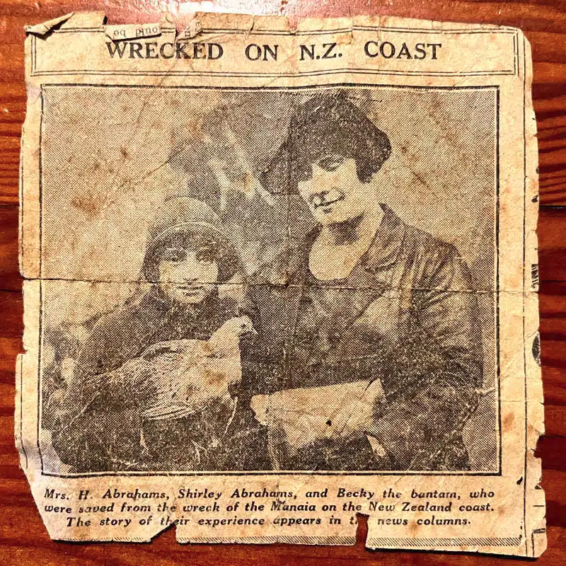
‘My mother, Shirley Abrahams, was the girl with the bantam rooster.’ – Kim White, 2022
Courtesy of Maritime Radio

Among the Manaia’s passengers were 24 members of the Stanley M’Kay Pantomime Company, which included a girl named Shirley Abrahams and her pet rooster Becky – the gift of an admirer in one of the towns visited by the company.  According to one report:

When the Manaia struck, the first thoughts of the young actress were of her pet. Forgetting her other treasures, she flew to Becky. He had been with her for over a year … He snuggled in the crook of her arm on board while awaiting the arrival of the Ngapuhi. Becky accompanied his owner in the lifeboat and was with her all the time on the Ngapuhi. Now he is on his way to Sydney with her on the Marama.

SS Manaia listing, before slipping into deep water

On 29 June, the Auckland Marine Court of Inquiry into the wreck found that the course set by Captain Norbury was a safe one - used without mishap by other steamer captains for many years. It found that like the steamer City of Winchester, which was crossing the Bay of Plenty at the time, the Manaia ‘had been carried inshore and off her course an abnormal distance … owing to a strong set inshore’. Norbury was held blameless, and his master’s certificate was returned.

In 1961 part of the steamer’s propeller was recovered by divers, by which time the ship had broken up and been under water for over 35 years. Today, the Manaia’s boiler and other equipment left behind on the reef and seabed make Manaia Reef a playground for snorkelers and scuba divers.

References

Bay of Plenty Times, 12 June 1926: 3, 14 June 1926: 3, 29 June 1926: 3.

Evening Post (Wellington), 11 June 1926: 8. 12 June 1926: 8, 14 June 1926: 10.

1926: SS Manaia strands on slipper Island, maritimeradio.org, https://maritimeradio.org › Distress

S.S. Manaia Ohimnemuri Regional History Journal. 40, September 2000, https://www.ohinemuri.org.nz › journals › s-s-manaia

Images

Sladden, Bernard, View of Northern Steamship Company SS Manaia on rocks, Slipper Island, wrecked on 10-Jun-1926. Ms 33/5/159. Te Ao Mārama, Tauranga City Libraries.

Slipper Island, New Zealand Herald. Privately owned island sells for more than $7m. NZME. 16 April 2015, nzherald.co.nz/business

Photographer unknown, SS Ngapuhi on Manukau Harbour. Ref. 4168. Auckland Council Libraries.

Photographer unknown. Wrecked on the New Zealand Coast, 1926: SS Manaia strands on slipper Island, maritimeradio.org, https://maritimeradio.org › Distress

Sladden, Bernard. View of SS Manaia wrecked off Slipper Island, 10 June 1926, Ms 33/5/206. Te Ao Marama, Tauranga City Libraries

Friday, 4 September 2020

When the Nellie Hit Astrolabe Reef

Motiti Island (Courtesy of Te Ara)

It was a clear moonlit night on 13 January 1878 when the 77 foot long schooner Nellie, owned by G.W. Owen, a flour and grain merchant, headed from Lyttelton to Auckland. Her 59 tons of cargo consisted of oats, flour, malt and bacon.

All crew were on deck: Alexander George Armstrong, the captain; William Candy, the mate; Frank Silva, able seaman; Charles Hannaford, the cook; and a seaman called Nelson. At 7.15pm, when within a mile off Motiti Island, they changed from starboard to port tack. Changing the watch, Captain Armstrong replaced Candy at 8pm, and Silva took the wheel from Nelson. The wind was westerly and seas were smooth. Having taken bearings, Armstrong believed the vessel was safe and he went below. There was no lookout and about 8.20pm the Nellie, doing five knots with all sails set, struck Astrolabe Reef.

Northern tip of Motiti Island, Wairanaki Bay at right, 9 Jan 2012
Photograph by Brett Payne (All rights reserved)

Armstrong rushed on deck. He ordered the foresail and mainsail to be lowered and told Candy to haul the jib sheet to windward and back the vessel off. Using the headsails, she came free, as Armstrong was thrown against the wheel, and injured his chest. The Nellie was filling fast with water, so he ordered the men to man the pumps while he headed for the sandy beach on the east of Motiti Island. But steering became unmanageable, and he requested clothing and provisions to be put in a boat. Unable to reach the beach, Armstrong ran the ship on to rocks at the north of Motiti Island. When ashore, he employed local Maori to remove the cargo, and farmer, George Douglas, loaned him his boat to report the disaster.

A preliminary enquiry was held in Tauranga before Dugald McKellar, collector of customs, and Captain Hannibal Marks, Tauranga pilot and harbourmaster. Armstrong, Candy and Silva gave evidence and details were wired to the Marine Department in Wellington. Next evening Armstrong returned to Motiti in Douglas's boat with E.G. Norris, the agent for NZ Insurance, which insured the hull. Union Insurance covered the cargo. 

SS Staffa and Captain Baker (inset), c. 1876-1881
Composite copy print courtesy of Tauranga City Library, Ref. 04-593
Original cabinet card of SS Staffa held by Whakatane Museum, Ref. P5777
Original source of portrait of Captain Charles Baker unknown


The insurance companies chartered the SS Staffa, which serviced the route between Tauranga, Opotiki and East Cape, to deliver the salvage to Tauranga, and the SS Rowena to take the cargo and lumber from the Staffa to Auckland. But salvage was delayed due to foul weather. Captain Charles Baker of the Staffa finally made it ashore at Motiti on the 18 January. He found the wreck broadside on the rocks with her bottom out, masts adrift, and unlikely to hold together much longer. About 40 tons of cargo had been landed, mostly undamaged.

The Marine Department’s Judicial Enquiry, held in Tauranga on 24 June 1878, was before JPs Edward Mortimer Edgcumbe and Major David Scannell, and nautical assessor Captain Joseph Ellis. Barrister Oliver Macey Quintal represented the Crown. Mr Brookfield appeared for Captain Armstrong and told the court bearings were taken all the way from Mayor Island. Water was too deep to take soundings, but Armstrong believed they were within a quarter and half a mile clear of the reef. He had told Silva to keep a good lookout. Candy said the Captain always instructed him to keep a lookout, and Hannaford told the court Armstrong consulted his charts and was always on deck in bad weather. But Silva insisted he’d not been told to keep a lookout, and stated the Captain had gone below to light his pipe. As there had been no special lookout the court decided the wreck was entirely Armstrong’s fault. His certificate was suspended for a month and he was to pay £2.15.0. in costs.

References

PapersPast - Bay of Plenty Times. 16, 23, 26 & 30 January 1878, 20 & 23 February 1878

'Motiti Island' map, from An Encyclopaedia of New Zealand, edited by A. H. McLintock, originally published in 1966. Te Ara - the Encyclopedia of New Zealand URL: http://www.TeAra.govt.nz/en/1966/24036/motiti-island (accessed 19 Aug 2020)

SS Staffa composite image also reproduced in, Our Opotiki: A Visit to White Island, in the Historical Review, Bay of Plenty Journal of History, Vol. 33, No. 2, Nov 1965

SS Staffa. Whakatāne Museum Ref. P5777 Original cabinet card print (109 x 167mm)

New Zealand Maritime Index http://www.nzmaritimeindex.org.nz/

Friday, 13 December 2019

Captain Jack and the Prince of Denmark Schooner, 1831-1832

Early Sailing Vessels and Visitors to Tauranga, Part VI.

Built in 1789 at Kirkudbright Scotland, on the Dee River, which flows into the Irish Sea, the 70 ton schooner Prince of Denmark spent most of its working life in Australian and New Zealand waters. Commissioned as a revenue cutter, Kirkudbright’s shipbuilders constructed a fast, relatively light schooner, intended to intercept smugglers. Though theoretically too light for these roles, the vessel spent long periods in the sealing and whaling trade from the 1820s, and frequently carried cargo and passengers between New South Wales and New Zealand. [1]

The harbour of Kirkudbright, River Dee, Scotland
Among the many skippers employed by her various Sydney owners was Captain Jack, an opportunist adventurer given to drink, like so many of his peers, who faced constant hardship and danger in their quest for profitable cargoes. In early 1831, he took the Prince of Denmark into Tauranga Harbour to complete his cargo of flax, timber and salted pork, before returning to Sydney. Captain Jack found the various Tauranga hapu still in a state of excitement, having defeated an amphibious, predatory expedition of Ngapuhi and Ngati Kuri from the Bay of Islands a few months previously. [2]

Led by the Ngati Kuri tohunga Te Haramiti, the invading 150-200 strong musket taua (expedition), had voyaged southwards to the Bay of Plenty in seven waka taua (war canoes,) transporting two ships’ cannon. After surprising, killing and enslaving some Ngai Te Rangi people on Tuhua (Mayor Island), they crossed to Motiti Island and camped on Hurepupo, a plateau (long since eroded away) at the centre of the spit where it curves away to the old Matarehua Pa. [3]

The invaders were then surprised by a combined amphibious force of 1000 Ngai Te Rangi, Ngati Haua and Te Whaktohea warriors led by their respective rangatira Hori Tupaea, Te Waharoa and Titoko. Following a fierce exchange of musket fire and hand to hand fighting the invaders were defeated and Te Haramiti was killed. The enemy slain were cooked and devoured, and their waka, cannon, muskets and heads seized as trophies by the victors. After returning to Tauranga, the victors sold the toi moko  or cured tattooed heads of 14 northern chiefs to Captain Jack. [4]

Motiti Spit, the site of 1831 battle and the long vanished plateau of Hurepupo
When the Prince of Denmark returned to the Bay of Islands on 16 March 1831, the missionaries Henry Williams and Thomas Chapman went on board and were horrified when they saw that many of the toi moko were ‘relatives of the principal chiefs at the Bay of Islands.’ [5] Undeterred by their remonstrations:
The master of the ship in a state of tipsy jollity, brought up a sack containing twelve heads and rolled them out on the deck. Some of the New Zealanders on board recognised their fathers’ heads, others those of brothers, and friends. Appalling weeping and lamentations rent the air, and the natives fled precipitately from the ship. [6]
A Dreadful Recognition: Captain Jack displays his tattooed heads
Before they left the vessel, the Ngapuhi visitors swore vengeance. Fearing a taua ito or blood vengeance raid, Captain Jack and the Prince of Denmark promptly departed for Sydney. There, the missionary leader Samuel Marsden also went aboard. After viewing the 14 toi moko, Marsden made strong representations to the New South Wales authorities. Governor Darling banned the New Zealand head trade later that year. [7]

Undeterred, Captain Jack was soon back trading in New Zealand waters. In 1832, during Ngapuhi’s artillery siege at Otumoetai Pa he again took the Prince of Denmark into Tauranga Harbour. When they recognized the schooner, the Ngapuhi artillerymen bombarded the vessel from the shore. Once again, Captain Jack was compelled to make a rapid departure to escape their wrath. [8]

In the remaining years preceding the Treaty of Waitangi and long after, the Prince of Denmark continued its role as whaler, trader and a passenger vessel, conveying a mix of missionaries, whalers, sawyers, colonists and colonial officials across the Tasman Sea. In 1863, following 74 years of service, the Prince of Denmark was driven ashore in a storm and wrecked at a remote whaling station in the Coral Sea’s Chesterfield Island group. [9] The fate of Captain Jack is unknown.

Endnotes
[1] Prince of Denmark, marinersandships.com.au
[2] Kirkudbright’s Prince of Denmark, by David R. Collin, https://www.whittlespublishing.com
[3] Bentley, Trevor, Tribal Guns and Tribal Gunners, WilsonScott, Christchurch, 2014: 62-64.
[4] Rusden, G. W. History of New Zealand, Vol I: Chapman and Hall, London, 1883: 133.
[5] Williams, Henry, The Early Journals of Henry Williams, 1826-1840, L.M. Rogers (comp.), Pegasus Press, Christchurch, 1961: 174.
[6] Thomson, Arthur, The Story of New Zealand, Vol. II, John Murray, London, 1859: 263.
[7] Marsden, Samuel, The Letters and Journals of Samuel Marsden, 1765-1838, J. Elder (ed.), Coulls Sommerville, Dunedin, 1932: 498-499.
[8] Yate, William, An Account of New Zealand, Seeley and Burnside, London, 1835: 131.
[9] Prince of Denmark Schooner, Australia, https://www.wrecksite.eu/wreck.aspx?55532

Illustrations
1 The Harbour Kirkudbright, www.kirkudbrighthistorysociety.org.uk
2 Motiti Spit, Motiti Island, Bay of Plenty, author’s collection.
3  Arthur McCormick, ‘A Dreadful Recognition,’ in Horsley, Reginald, Romance of Empire: New Zealand, T.C. and E.C. Jack, London, 1908: 122.

Friday, 13 September 2019

Charles Spencer (1854-1933) – Part III – Serving the Community

S.S. Taupo, as she lies on the Rocks at Stoney Point, Tauranga Harbour
Photographed at low water on the afternoon of April 9th [1879], by Charles Spencer
Albumen print mounted on printed card, Tauranga City Library, Ref. 05-445

The s.s. Taupo ran aground on Stoney Point Reef in the entrance to Tauranga Harbour on 18 February 1879. Several attempts were made to raise her off the rocks over the next two years, eventually succeeding on 2 March 1881, although she sank a few weeks later off Tuhua while being towed to Auckland. This large format photograph by Charles Spencer was supposedly taken on 9 April – although the year wasn’t specified, it is likely to have been in 1879, three weeks after the accident, and only a week after Spencer’s arrival in Tauranga.

Portrait of (back row) Edward Ker Mulgan and Everard F. Buckworth,
(front row) William Tuthill and George Noble Gair
Carte de visite by Charles Spencer, Tauranga, April-June 1879, with annotations on verso
Alexander Turnbull Library, Ref. PA2-1686
G.N. Gair arrived from Wellington on 25 May 1878 to take up the position of manager of the local Bank of New Zealand branch. Having purchased a farm and an allotment in the Quarter Acres, he quickly became involved in the local scene, being appointed to several committees, engaging in amateur dramatics, and endearing himself by playing a prominent role in fighting a fire which broke out in a shed on the Town Wharf in late September. He was Treasurer of the Tauranga Cricket Club, and no doubt a frequent player. He participated in Tauranga’s annual St Patrick’s Day Regatta in March 1879. Sadly, he took his own life on 26 June 1879. The names of Mulgan, Buckworth and Tuthill appear frequently in the newspapers of that period in connection with cricket, boating and horse racing, and it seems likely that the carte de visite above celebrates one such event. It was taken by Spencer soon after his arrival in Tauranga, probably in his tent adjacent to Wrigley’s Brewery. Other carte de visite portraits in an identical format by Spencer held at the Alexander Turnbull Library depict other Tauranga personalities, including John E Grace and Fred Clarke, and were probably also taken c.1879-1880.

Lake at White Island, partially dry, c.1882-1884
Glass plate positive by Charles Spencer (Series # 107)
Auckland Library Sir George Grey Collection, Ref. 1285_09999

In November 1882, March 1883 and again in February 1884 Spencer made trips to Whakaari (White Island), partly to take photographs, but also to evaluate the prospects of extracting sulphur, to be used in the manufacture of fertilizer and sulphuric acid. In May 1883 he accompanied a survey party to Karewa Island, and brought back not only some exposed glass plates but some specimens of tuatara which he displayed in his shop window.

Children at a Maypole Dance, probably at the Temperance Hall, Tauranga
Cabinet card albumen print attributed to Charles Spencer, 25 February 1886
Tauranga Heritage Collection, Ref. 0569-08

In March 1884, when the Governor visited, he captured both the reception given him at Whareroa Marae and the subsequent speeches celebrations along the Strand from an upstairs window. During a Maypole Dance conducted on 25 February 1886:
“Mr Charles Spencer succeeded in taking a couple of photographs of the group, which we doubt not will appear in due course with the impress of this gentleman’s well known finish and prove to many a pleasant souvenir of the Wesleyan Gift Auction.”
It is almost certain that the cabinet card illustrated above is one of these photographs, even though it does not have Spencer’s name on it. At the same event there was a magic lantern show, “at which will be shewn a number of well-known views,” probably also conducted by Spencer.

Sailing Regatta in Tauranga Harbour, c. mid- to late 1880s
Carte de visite albumen print attributed to Charles Spencer
Tauranga Heritage Collection, Ref. 0572-08

Likewise this carte visite photograph of small yachts competing in a regatta on Tauranga Harbour, with the Papamoa Hills visible on the skyline, was almost certainly by Spencer. A regatta was held annually in Tauranga in mid-March, although there were smaller meets as well. Spencer donated prizes for the regatta comprising sets of his photographs of the Hot Lakes in 1887 and 1889, and it is possible that the above view was taken on one of those two occasions.

Charles Spencer was elected to the Borough Council in May 1887, but failed in his bid for the Mayoralty in December that year.

(to be continued)