Showing posts with label Postcard. Show all posts

Friday, 21 February 2025

Beazley's Pre-Cut Houses

Construction of Beazley Homes’ admin block, Hull Road, Mt Maunganui, November 1966
120-format film negative, Published in the Bay of Plenty Times, 9 Nov 1966
Collection of Te Ao Mārama - Tauranga City Libraries, Pae Korok
ī photo gca-13802

In 1950 local father and son home builders, Barry and Fred Beazley, began expanding throughout the North Island. By 1961 they were in the South Island and a year later the company Beazley Homes Ltd. came into being with its head office at Hull Road, Mount Maunganui.

Aerial view of Beazley Homes’ yard, Hull Road, Mt Maunganui, c. October 1966
35mm-format film negative, Unpublished Bay of Plenty Times photograph
Collection of Te Ao Mārama - Tauranga City Libraries, Pae Korok
ī photo gcc-11112

They occupied a large block of land which included the timber yard, Mount Timber and Hardware, the truss plant, the moulding shed and the pre-cut division. The main entrance to the yard was off Hull Rd. The company was known for its pre-cut timber frames that could be sent all round New Zealand and the Pacific.
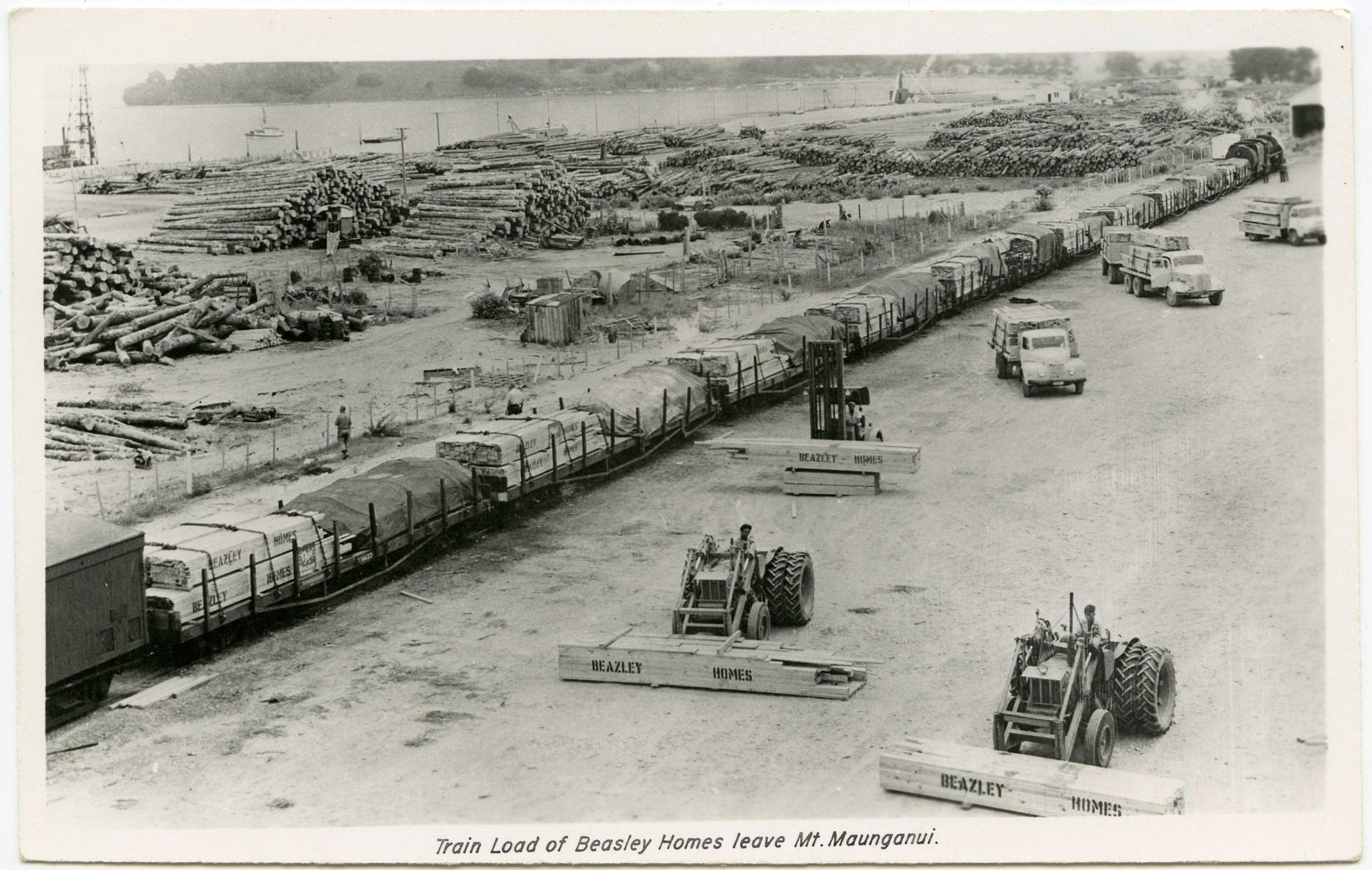
Train load of Beasley [sic] Homes leave Mt Maunganui
Black-and-white postcard (140 x 88 mm), publisher unknown
Tauranga Heritage Collection, Ref. 0039/11

The pre-cut division was staffed with approximately twenty people; one quantity surveyor, three draughtsmen and seventeen others whose job it was to set out the plates and frames, cut the roofs and studs and pack up each completed house lot.  A train came in to the rail siding each day to pick up the wagons loaded with the pre-cut houses. Forty went out each week to franchise builders from Whangarei to Wellington.

Beazley Homes Ltd brochure, c. 1970s
Tauranga Heritage Collection, Ref. 0390/24/1-28

In 1974 all the plans and quantities had to be changed from imperial measurement to metric – a massive job as every measurement on the plans were affected. As a cost saving exercise Beazleys decided to change all inside walls from 4x2 to 3x2 and so all the plans and quantities had to be changed again. After six months it was discovered that 3x2 walls couldn’t keep the studs straight so the plans had to be changed back again.

Beazley Home exhibit at Trades Fair, October 1966
(Detail) 120-format film negative, Published in the Bay of Plenty Times, 11 Oct 1966
Collection of Te Ao Mārama - Tauranga City Libraries, Pae Korok
ī photo gca-13393

The completed houses left Beazleys like giant flat packs and were loaded onto ships at the wharf for the Maldives, Papua New Guinea and Australia. The pre-cut houses sent to Australia were destined for miner’s homes at Mt. Tom Price and a hundred at a time went to Weipa in far north Queensland. One delivery of a hundred arrived there without the kitchens, there was a ‘slight delay’ as the kitchens caught up with the rest of the houses. Hurricane bolts were sent for each corner of the house to prevent the houses from being blown apart during a cyclone.

Pre-built Beazley Homes Ltd. accommodation unit for export market on back of truck, 1977
Fletcher Holdings Archives, Ref. P9006/6

Beazleys sold out to Fletchers in 1973. Pre-cut houses have been replaced by pre-nailed frames and the pre-cut roofs with trusses.

Sources

Fletcher Trust Archives
www.nzherald.co.nz
Pae Korokī Tauranga City Library
Selwyn Neal
Tauranga Heritage Collection

Friday, 27 September 2024

The Wreck of the SS Tasman

Located off Matata, the low lying Rurima Islands or Rurima Rocks, were brought to the attention of Tauranga’s residents by the Bay of Plenty Times on 12 May 1921. At 4.25 a.m. on the 11th, the Northern Steamship Company steamer Tasman struck a reef near the south-western rock while steaming to Whakatane. The passengers and crew were saved, but the ship was lost along with all cargo and mail. The passengers and crew came ashore without their luggage and personal effects at Matata and Pikowai in three lifeboats, before being transported in trucks to Tauranga.[1]

The Northern Steamship Company vessel SS Tasman

Built in Auckland in 1903, the 179-ton kauri and iron steamer was 102 feet in length and powered by 280hp compound engines.[2] Placed on the Auckland to Whakatane run by the company, the SS Tasman was a regular sight at Tauranga’s Victoria Wharf between 1909 and 1921. There, it offloaded and took on new passengers, freight and mail, as well as coal for its boilers.

A Nautical Inquiry into the wreck of the SS Tasman held at the Auckland Magistrates Court the following month, expressed focused on four issues:

  • The chief officer Mr. McManus was on watch and in charge of the Tasman with Captain William John Grigg also on the bridge when the vessel struck.
  • Though the weather was squally, it was possible to see the higher points of the Rurima Group and also Whale Island. The vessel struck an island which could be seen at the time the accident occurred.
  • When the steamer struck on the south-west point of the Rurima Group, there was about three miles of shore room between the shore and where the incident occurred.
  • The course was a perfectly well-known one and had been run in perfect safety for the last 50 to 60 years and the Tasman was jammed for time to catch the bar at Whakatane.
The Rurima Islands
The SS Tasman struck a reef on the south-west corner of the Rurimu group

In evidence, Captain Grigg stated that he had been master of that steamer about three or four months before May 11. He had also been master of the Tasman at different periods and had originally been chief mate of the Tasman for close on three years. During that time the steamer had been wholly engaged in the Auckland to Whakatane trade. He had also been master of other vessels in the Northern Company’s fleet.

On the night of the disaster, he had kept a course close inside Mayor Island, which was passed at about 10 o'clock. He had followed his usual course, which he had always found a safe one, inside Whale Island. When passing Motiti Island the weather was clear, with no sea and just a medium breeze.

He was below when the mate called him at ten minutes to four, and told him they were close to Matata light, which was then just for'ard of the starboard beam. At this time, they were about two miles off Matata. As several other “objects” were in view, and Grigg "took a shot" at them over the steering compass, but took no other steps to place them accurately.

While the weather then was ‘fairly clear’ overhead, they were surrounded by black clouds. The wind was fresh, with squalls at times, from the S.S.W. Shortly after, the mate observed that the land was a little closer and altered the course half a point to the southward. A few minutes later the Tasman struck. The time was then within a few minutes of 4.25. He thought the vessel struck at the south-west corner of the Rurima Group.

According to the mate, the vessel did not seem to rest on the reef for any appreciable time, and backed her off, he steered straight for the mainland. SS Tasman sank scarcely a mile off Rurima.

Captain Grigg stated that he could have gone outside Whale Island that night, but there was smoother water on the inside. Mr. McManus, he said, had been his chief mate all the time he was on the run, and he had found him perfectly reliable as a navigator.[3]

A coastal steamer at Victoria wharf 1810s

On 9 June, the Nautical Court of Inquiry found that the SS Tasman was off her proper course when it struck one of the Rurima rocks and was wrecked. The first officer was adjudged negligent in not ascertaining his correct distance off' the land at Town Point (Maketu). The court also found that Captain Grigg, the ship’s master:

[D]id not exercise good judgment when deciding what distance the vessel was off the land at Matata. The court was further of the opinion that when the chief officer drew the master’s attention to the ship’s closeness to the Rurima rocks, the master, in sending a message to the officer on the bridge to alter the course a quarter of a point to the south, was not taking sufficient precautions for the safety of the vessel.[4]

Despite being found guilty of negligence and fined 20 and 10 pounds respectively towards the costs of the inquiry, Grigg and McManus did not lose their certificates.[3] Evidence had been put before the court that, in the vicinity of White Island, the needle of the compass would be liable to be deflected by the magnetic disturbance which existed at the time the grounding occurred.[5]

Sinking just 30 minutes after its initial grounding, the remains of the SS Tasman - the boiler, part of the hull and the engines - lie in 27 meters of water between the Rurimas and Matata.

End Notes
[1] Bay of Plenty Times, 12 May 1821: 3.
[2] Rurima Island, Wikipedia, https://en.wikipedia.org › wiki › Rurima Island
[3] Auckland Star, 6 June 1921: 7.
[4] New Zealand Times, 10 June 1921: 5.
[5] Ibid: 10 June 1921: 5.

Illustrations
[1] H. Winkelmann, SS Tasman 1903-1921, Auckland Weekly News, 19 May 1921, Auckland Council Libraries - Kura AWNS-19210519-43-01
[2] Photographer unknown, Rurima Islands, Wai 46 # A3, Te Rangahau Whenua Raupatu O Ngati Awa Report to Department of Conservation, 25 July 1992: 15.
[3] Frederick Radcliffe, Postcard, Tauranga, Victoria Wharf, 1910s. Accession number 0846/08. Tauranga Heritage Collection

Friday, 14 May 2021

The Tauranga Bowling Club - Early Beginnings

The Bowling Green, Tauranga
Postcard by Rendell, Collection of Justine Neal

On the 21st April 1898 a meeting was held in Mr. Thomson’s office of those interested in bowling. Mr. Samuel was elected to the chair and in opening the proceedings said that every town of importance in the colony had its green where those of a social nature could meet and engage in one of the oldest English past times. He said the game of bowls promoted health and sociability and established friendships which lasted a life time, besides which there was a species of freemasonry amongst all the bowlers of the colony.

A committee of five were appointed and by July of that year a contract had been let for the formation of the bowling green which included maintenance during the season. It was reported in September that the bowling green was looking well and should be ready for use at the beginning of the season.

Tauranga Domain, Photograph by P. Browning
Postcard published by AH & AW Reed (SR615), Collection of Justine Neal

The great day of the opening was held on Thursday, 2nd February, 1899. By this time about forty gentlemen has intimated that they would become members. A large number of ladies and gentlemen assembled at the new green which was alongside the tennis court and had actually been leased from the tennis club. The first game which was closely watched by the visitors lasted a little over two hours. The condition of the green was stated to be more in favour of the beginners than experienced players as the unevenness of the surface prevented the bowls taking the proper bias while in many cases they ran off in a contrary direction to that intended. Complaints were also made about the heaviness of the ground which compelled players to use a good deal of strength to get their bowls to the jack.

The defects of the green were tackled in April, 1899 when it was levelled and top- dressed. However during the night someone sowed it with a mixture of cow grass and dock seed which led to a reward being offered for the conviction of the culprits.

On the 3rd November 1899 the Bay of Plenty Times reported that the Tauranga Bowling Club was favoured with beautiful weather for its opening yesterday. Mrs Westenra provided afternoon tea for a numerous gathering of ladies and gentlemen who apparently enjoyed the good fare, and a thoroughly enjoyable afternoon was spent.

Mrs Humphreys took several photos during the afternoon of the players and assembled guests.

References
Tauranga 1882-1982.
Papers Past, Bay of Plenty Times 1899.

Friday, 2 October 2020

Wairere Waterfall

Wairere Falls, Whakatane. Photograph by C.G. Caisley (No 153)
Published by Frank Duncan & Co., Auckland (PM 1919)
Collection of Justine Neal

Tumbling down the cliffs immediately behind the township tall, skinny Te Wairere occupies a cool nook and a place in the early history of Whakatane. The falls were one of three landmarks given to Toroa, captain and navigator of the Mataatua waka, by his father Irakewa, in his search for Whakatane. The other two being Te Ano o Muriwai (Muriwai’s Cave) and Te Toko o Irakewa (Irakewa Rock). As well as being a sacred landmark Te Wairere Falls were a source of fresh water for the Ngati Awa people living at Te Whare o Toroa Pa. When the town itself was still small the falls were used for the setttlement’s first water supply and the stream continued to supply water to the Whakatane township until 1924.

The Fulloon whanau had land below the waterfall and it was here in 1865 that James Francis Fulloon was first laid to rest beside his mother’s grave. James was a native interpreter. In 1865 he was commissioned as a captain in the militia and set off by sea in the Kate for Whakatane to recruit a company of Ngati Awa to counter Pai Marire influence in the Bay of Plenty. His own people, however, had embraced the Pai Marire faith and James and most of his shipmates were killed. In 1913 his remains were moved by his sister to a new burial site at the Domain Road Cemetery.

Wairere Falls, Whakatane. Photograph by C.G. Caisley (No 159)
Published by Frank Duncan & Co., Auckland (no date)
Collection of Justine Neal

The falls are also associated with early industry. Flax mills need a lot of water for washing the fibre and soon after 1870 a mill was built at the falls; it was wrecked by a flood in 1875. In 1878 the government purchased the old flax mill buildings and machinery at Wairere for a flour mill site. The mill was driven by a Pelton Water Wheel and the water was piped from the top of the falls where there was a small concrete dam to pond the water.

On December 18th 1879 the large hall at the old flax mill site caught fire. The flames quickly caught hold and nothing could be done to stop it. Fortunately the plentiful water supply from the Wairere Falls saved the sawn timber for the Ngati Awa flour mill which had been stacked near the burning building.

By 1890 wheat growing had declined so much that there was not enough to keep the mill going and it was converted into a flax mill which burned down in 1910.

In 1907 the Rotorua Motor Coaching Company built stables at the foot of the falls for their horses, the stables were later used for a garage when cars replaced horses. A fire in 1928 destroyed the garage.

The site was made a scenic reserve in 1971, a peaceful place with the water cascading down the cliffs the way it always has long before Toroa first sighted it.

References
Whakatane Historic Trails
Papers Past
A Man of Two Cultures, W.T. Parham
www.whakatane.com

Tuesday, 5 November 2019

Waikato Hounds in Tauranga

Waikato Hounds in Tauranga. Postcard by Talma Studios (41), c. 1910-1914
Image courtesy of Tauranga Heritage Collection, Ref. N4F4D5

At the beginning of the 20th century the Waikato Hounds were regular visitors to Tauranga and were hosted by the Tauranga Hunt Club, which was formed in 1897. Hunt Club members were from well-known Tauranga families and many of the hunts ranged across Otumoetai farms owned by Tollemache, Matheson, Baigent and Darragh.

Unfortunately the exact date of this photograph is not known although it is thought to have been taken between 1910 and 1914. The group appear in front of the Tauranga Hotel on the corner of Harington Street and The Strand.

Tuesday, 8 October 2019

A Game of Croquet

Group playing croquet. Photograph attributed to Mary Humphreys
Postcard, Image courtesy of Tauranga Heritage Collection, Ref 0213/08
This postcard was donated to the Tauranga Heritage Collection by Mrs Kay of Mount Maunganui in 1982. It shows a group of women and two girls enjoying a game of croquet at the Tauranga Domain. A croquet club was established at the domain on 8 November 1902 under the umbrella of the Bay of Plenty Lawn Tennis Club. The clothing suggests that this photograph could have been taken around that time period.

While the photographer is not known, it seems likely to have been local photographer Mrs Mary Humphreys. Her daughter, Miss Connie Humphreys, is recorded in the Bay of Plenty Times as being a member of the club.