Showing posts with label Ngaiterangi. Show all posts

Sunday, 25 May 2025

Hopukiore

Ocean Beach and Hopukiore (Mt Drury) from Mauao, Mount Maunganui, c. early 1950s
Postcard, unidentified publisher, collection of Justine Neal

Hopukiore, at 40 metres high is much smaller than its famous counterpart, Mauao but it’s history is just as fascinating. From the late 1500’s the Ngati Tauaiti had a marae there, along with another marae on Moturiki. The name Hopukiore means to catch kiore (rats), the bones and the teeth of which were used for carving chisels and tattooing instruments. The area was used as a carving school and a wahi tapu (sacred site) for ta moko (traditional tattooing).

Ocean Beach, Mt. Maunganui, c. 1970s-1980s
Postcard published by Pictorial Publications Ltd, Hastings
Collection of Justine Neal

On the eastern side of Hopukiore there are at least five caves, some of which are known to have been used for burials. The 1820 battle fought between Ngapuhi and Ngaiterangi resulted in a large number of deaths for the Ngaiterangi. Te Waru’s (Ngaiterangi) chivalrous treatment of Te Morenga (Ngapuhi) after the battle led to peace between the two tribes and the Ngaiterangi dead were honoured with burial in the caves of Hopukiore.

East Cave, Hopukiore, 2025
Photograph by Justine Neal

The caves were also used by the men of the 80th Regiment under Major Bunbury when they were sent from Auckland to deter hostilities between Arawa and Ngaiterangi, occupying the hill from December 1842 to March 1843. One cave was enlarged and shelves installed for munitions storage and a door was fitted. Another two caves were used for general storage and a bakehouse.

Hopukiore (Mt Drury) and Mauao, from Marine Parade, Mt Maunganui, c. 1950s
Collection of Tauranga Libraries, Pae Korok
ī Ref. Photo 99-028

In the 1980’s two young local boys were amusing themselves using old boxes to slide down the slopes of Hopukiore,  After a while, as they happened to have a small torch with them, their attention turned to the caves and they decided to do a little exploring. On entering the cave it felt cold and damp, the floor was hard packed dirt and there was enough headroom to walk. The cave narrowed, then came a shoulder height drop but they were still able to walk down to the next level. The cave narrowed again, it appeared to be solid rock in front of them but the torch showed that in one place the rock overlapped leaving a narrow gap to squeeze through. There was no way an adult could manage it but the boys thought they would be able to. At that moment they had a couple of choices and sensibly decided the way back was the safest one.

In 1853 Hopukiore was given the extra name of Mount Drury, named after Commander Byron Drury who arrived in Tauranga in 1852 on board the H.M.S Pandora to complete a coastal survey of the Bay of Plenty started in 1848.

Hopukiore (Mt Drury) from the quarry on Moturiki, Mount Maunganui, 1921
Postcard by unidentified publisher
Tauranga Heritage Collection, Ref. 0197/08

In 1913 a railway line that had been built to the railway workshops (situated between Salisbury Avenue and Rata Street) was continued up the main street, curving round the northern end of Hopukiore to service the quarry on Moturiki. A crushing plant had been built on the foreshore of Hopukiore to deal with the stone coming from the quarry.

The big swing at Mount Drury (Hopukiore) playground, Mt Maunganui, January 1967
120-format film negative, published in Bay of Plenty Times, 13 Jan 1967
Collection of Tauranga Libraries, Pae Korok
ī Ref. Photo gca-14286

Mrs. Gilchrist in the book ‘A History of Mount  Maunganui’ by Don Cunningham remembers the Public Works picnics:

“When they got the rail through a bit they would have open carriages with seats across and you’d come down to the Mount from Te Puke. The railway line went right along where the Main Road is now. We would all get off at the foot of Mount Drury on a platform and then take our picnic baskets into the big pine trees.”

Tunnel of the Mt Drury (Hopukiore) Railway Line, Mt Maunganui, December 1966
Crop of 120-format film negative, published in Bay of Plenty Times, 28 Dec 1966
Collection of Tauranga Libraries, Pae Korok
ī Ref. Photo gca-14079

From 1960 to 1975 there was a miniature railway as part of a children’s playground. There was a man-made tunnel that it went through at the base of Hopukiore and that’s where it lived. There were doors at each end that were kept locked when it wasn’t in use. It only used to run in the summer. Since 2008 there has been a playground on the western side of the reserve.

Mount Drury Tower (Hopukiore), Mt Maunganui, February 1963
120-format film negative, published in Bay of Plenty Times, 26 Feb 1963
Collection of Tauranga Libraries, Pae Korok
ī Ref. Photo gca-4488

In 1958 the Harbour Board Signal Station was erected on the summit of Hopukiore, the ideal place with its sweeping views out to sea. It served as a communication tool for navigation and relaying important information to the ships. It has been inoperative for many years now and at the present time only the signal station mast and a shed remain on the site.

Hopukiore (Mount Drury) with Soundshell, taken from Moturiki (Leisure Island), c. 1970s
Silver gelatin snapshot print by unidentified photographer
Tauranga Heritage Collection, Ref. 0040/25

In 1967 a Soundshell was built on the flat surface at the base of Hopukiore on the Moturiki side. The seating was provided by man-made terraces or by spreading a towel or a blanket on the grassy slopes. It proved very popular with locals and visitors alike, and was regularly used for concerts and events, such as the Miss Mount Maunganui contest on New Year’s Day. The Soundshell was demolished in 1999 and the area reverted back to grass.

Mount Maunganui 5,000 Club junior pageant at the Soundshell,January 1967
120-format film negative, published in Bay of Plenty Times, 4 Jan 1967
Collection of Tauranga Libraries, Pae Korok
ī Ref. Photo gca-14153

In 1978 the Council decided to extend the Grace Avenue frontage of Hopukiore by buying the small cottages that had been built there. These worker’s cottages were relics of the days when Moturiki had been quarried by the Railways Department and coincidentally several of them came on the market at this time and others were obviously reaching the end of their useful life.

Radio mast and shed, Hopukiore, 2025
Photograph by Justine Neal

The Council employed a land agent whose job was to enquire from the landowners if they were interested in selling. Unfortunately, he rather overstepped his job description by threatening them that if they did not sell the Council would take the land under the Public Works Act. Eventually the cottages were acquired by the Council and the land incorporated into the reserve. It just took a little bit longer and without the help of that particular land agent.

References

2019 Tauranga Reserves Management Plan
Tauranga City Library
Tauranga Heritage Collection
Explore Tauranga

The Weekend Sun, 22 February 2013
Sunlive, 10 May 2021
A History of Mount Maunganui, compiled by Bruce Cunningham & Ken Musgrave, 1989

Friday, 14 July 2023

James Farrow and his Boat, 1829-1838

Tauranga's Early Traders, Part II

‘I came to Tauranga in 1829’, recalled James Farrow, the district’s first permanent Pakeha settler identified by name.1 Sometimes referred to as Farrar by later missionary arrivals who did not approve of his musket trading, the former merchant seaman with an entrepreneurial flair was born in London in 1800. Farrow originally landed at the Bay of Islands in 1825, with the object of exchanging muskets and gunpowder for cargoes of dressed muka (flax or Phormium tenax) for a Sydney trading house.2 As the Tauranga iwi were not yet fully armed with muskets, in January 1829, he voyaged there in own his sailing craft, which appears to have been a schooner rigged ‘boat’, with a quantity of muskets and general ‘trade’.3 On arrival he was ‘claimed’ by the Ngai Te Rangi people at Otumoetai Pa as ‘their’ Pakeha.

A semi-indigenised pre-Treaty Pakeha-Maori

In the interests of protection and profit, Tauranga’s pre-Treaty flax traders like Farrow lived among the different Ngai Te Rangi hapu around the harbour, becoming in due course a semi-indigenised Pakeha-Maori.
Artist unknown ‘A Pakeha Maori’, in Knox, Thomas W; The Boy Travellers in Australasia, Harpur and Brothers, New York, 1889: 203

Alone among Ngai Te Rangi, Farrow was, not unwillingly, assimilated by his tribe as a semi-indigenised Pakeha-Maori or ‘white man gone native’. Known as Hemi (James), he married an unidentified, high-born Ngai Te Rangi woman and became fluent in Maori but, while honouring a range of customs, retained his European dress and basic values. Farrow enhanced the power and mana of the Otumoetai people by fully arming them and, as the intertribal musket warfare swept the Bay of Plenty, ensured their survival as an entity. As with subsequent Tauranga flax trader arrivals who also became semi-indigenised Pakeha-Maori, Farrow lived in a superior house – in his case within Otumoetai Pa, built and decorated inside and out Maori-style by his whanau and hapu – accommodation befitting his value and status as a valued Pakeha rangatira or white chief and a conduit to European muskets, munitions and general trade goods.4 

Arthur Thomson, a British military surgeon and historian who encountered many former trader Pakeha-Maori during his North Island travels (which included Tauranga) during the 1850s, said of first arrivals like Farrow:

[E]very inducement was held out to white men to settle in the country; houses were built for them, land was given them, they were allowed to select wives from among the daughters of the chiefs and were not required to hew wood or draw water. In return for these royal privileges Pakeha Maoris were required to barter pigs, potatoes, and flax, for guns, blankets, tobacco and other articles.5                                                                                         

The house of a rangatira at Otumoetai Pa

Taylor, Richard, ‘Chief’s house, Otumoetai Pa, March 1839’. Richard Taylor’s Sketchbook, Auckland War Memorial Museum, Tamaki Paenga Hira. Ref: MS-302. PD-1961-14-p167-1

In 1829 Farrow, who found the Tauranga flax trade commercially viable, was joined by his brother Daniel. Both were associated with Otumoetai Pa until the 1860s, but little is known about Daniel who, while assisting his brother, lived in his shadow. The harbour offered sheltered anchorages where vessels could be easily unloaded and loaded. Ngai Te Rangi’s leading rangatira at Otumoetai offered protection from hostile tribesmen and guaranteed regular and substantial cargoes of dressed flax. Smaller vessels arriving from the Bay of Islands were loaded directly while beached on the sands below Otumoetai Pa at low tide, where Farrow later had a jetty constructed. Any larger Australia-bound vessels anchored in the Otumoetai channel or at Waikorere (Pilot Bay), where they were loaded from waka.

James Farrow’s years in pre-Treaty Tauranga were adventurous ones. In November 1830, the former privateer and whaler Phillip Tapsell sailed for Maketu, where he established himself as flax trader for the Arawa iwi. Farrow agreed to work as Tapsell’s Tauranga flax agent, a role with many attendant risks. Soon after, when Farrow voyaged to Maketu and uploaded a fresh cargo of trade goods, he and Tapsell retired to the latter’s house for refreshments. Seeing the opportunity, the Arawa rangatira Haupapa and his warriors seized the cargo and carried it off into the bush. Tapsell at once sent for Haupapa, who entered the house with young chief named Pipi. While Farrow blocked the door with his body, Tapsell placed a loaded musket to the head of Haupapa, who, calling out, ‘gave the necessary orders, and the goods were all restored’.6

During the early 1830s, James Farrow, while only in his 20s, exchanged muskets, powder, lead, tomahawk heads, rum and blankets with Ngai Te Rangi for huge quantities of dressed flax, pork and potatoes, which were shipped to New South Wales on vessels contracted by Tapsell’s employer, the Sydney merchant house Jones and Walker. The Tauranga flax trade initially proved profitable for all parties. By December 1830 for instance, the British Admiralty in London was purchasing cargoes for Royal Navy lines and rigging at £43 per ton. 7

Farrow’s cargoes were often loaded aboard vessels beached at low tide near Otumoetai Pa.

Ilene Stichbury, Unloading on the shore, Auckland. 1920s, Auckland Art Gallery Toi o Tāmaki, The Ilene and Laurence Dakin Bequest, Accession no. 1990/30/2

On another occasion, when Hakairo, another Arawa rangatira, invited Tapsell to establish a flax trade to Rotorua, he sent Farrow, his most trusted agent, with a quantity of trade goods pikaued or backpacked by a long line of Maori porters. After Farrow had purchased ‘80 or 90’ baskets of flax, he sent a message to Maketu informing Tapsell that Hakairo’s people had stopped scraping flax ‘and had begun to look upon the goods sent there as their own, which they could take when they pleased’.8 On Tapsell’s instructions, Farrow, his Maori wife and an American Negro assistant ‘very cleverly’ packed the remaining trade goods within the baskets of of flax they had purchased (average weight, 60 pounds apiece) which were then pikaued back to Maketu. The trio were fortunate, as Cabbage, a former Tauranga flax trader who later attempted a similar stratagem at Rotorua, was found out and killed. Hakairo vowed vengeance for the ‘theft’, but nothing came of the affair.9

Between 1830 and 1833, Farrow also traded with the rangatira Te Waharoa and his Ngati Haua iwi at Matamata Pa. Although the trade was intermittent, when it did occur, it involved large quantities of flax. Ships’ cargoes up to 70 tons in weight were distributed in back packs, borne by long lines of women and slaves by way of the Wairere track, over the Kaimai Range and down to Tauranga. The cargoes were shipped directly to Walker and Jones in Sydney by large vessels anchoring at the Te Puna (Wairoa) River mouth.10 Farrow recalled:


I had been in the habit of supplying Te Waharoa with guns and power among(?) other things… I used to go to Matamata. The N[gati] haua were supplying me with flax. They carried the flax from Matamata to Tauranga. They were cutting flax about Matamata, at Paparahi, and on the Waihou River at Waiharakeke (the main canoe landing on the Waihou River for parties of Maori visiting or attacking Matamata Pa]. Maori set great value on guns in former times. They would work day and night to get them.11

Farrow’s stock in trade included cast off military flintlock “Brown Bess’ muskets

Flintlock musket, Tower Armouries, circa 1800, London, DM000109 Gift of the Wellington City Council, National Museum of New Zealand, Te Papa Tongarewa

By 1832, Farrow had been joined by several competing flax traders at Otumoetai and in 1833, Tapsell appointed the former ship’s mate Edward Clementson as his flax agent at Matatmata Pa. Thereafter, Farrow increasingly used his ‘boat’ to collect dressed flax from tribes around the Bay of Plenty.12 In 1836 he was trading with Arawa at Maketu Pa, when it was stormed with great slaughter by Ngati Haua under Te Waharoa. Rescued by Ngai Te Rangi warriors who had joined the besiegers, Farrow emerged unscathed, but without his ‘trade’.13 Matamata’s Edward Clementson featured in another of Farrow’s adventures - a near drowning when his whale boat was swamped in heavy seas off Matata around 1838. Phillip Tapsell described the incident in his reminiscences.

He [Farrow], his wife and [Edward] Clementson, with a young man named Jenkins, set out in a whaleboat for Matata, with a view of meeting Mr. White there [a trader and ship builder], and when off the latter place, were overtaken in a gale of wind. It would have been easy for them to have run under the lee of Whale Island [Moutohora], where they would have had smooth water, and there to have waited till the storm subsided; but their young companion, being inexperienced and very confident, was strongly desirous that they should at once land at Matata, which he was of opinion they could easily do.

Yielding to this opinion, they pulled for the mainland, on approaching which, they found a very heavy surf breaking on the bar. Appearances were so threatening that, when near the entrance of the river, they lay on their oars to deliberate on the best course to pursue. They consulted so long that, before they were aware, the boat drifted into the breakers, and was capsized. Jenkins, not being able to swim, went down like a shot. Clementson was a good swimmer, but so encumbered with heavy boots, and buttoned up to the throat in a pea jacket, that, after a few strokes, he sank also, not to rise again. Farrow, though, also a good swimmer, would have given in from fatigue, but for his wife, who swam by his side, encouraging him continually with the assurance that the people were coming down to the beach, till he reached the shore in safety.14

A Pakeha trader bargaining with Maori for pigs and baskets of dressed flax and/or potatoes

Williams, John, Maori bargaining with a Pakeha, A-079-017 National Library of New Zealand, Wellington.

As the demand for muskets and Tauranga’s flax export trade declined, James Farrow prospered from the booming provisions trade in salted pork, potatoes, maize and wheat, which were sold directly to visiting vessels. Having acquired a degree of respectability as ‘an old hand’ or pioneer, he joined the Te Papa missionaries and fellow Tauranga traders in signing James Busby’s 1837 petition to the Colonial Office requesting protection from lawless Europeans.15

Farrow’s loyalty and service were recognised by Ngai Te Rangi on 10 January 1838. The leading rangatira Tupaea, Tangimoana and Te Omanu, permitted Farrow to purchase half an acre of land for his trading store at the western end of Otumoetai Pa, close to the foreshore. This acquisition was the earliest authenticated land purchase in the Bay of Plenty for which a Crown Grant was later issued.16 Unfortunately for posterity, no known image of James Farrow exists, but as we shall see, he also continued to play an important role in Tauranga events in the post-Treaty era.

Endnotes

1 Matheson, A.H; ‘Otumoetai Pa and the Early Times in Tauranga’, in Journal of the Tauranga Historical Society (Inc.), Vol. 52 December 1974: OT 14.2

2 James Farrow (c.1800 - 1880) - Genealogy - Genihttps://www.geni.com › people › James-Farrow. See also New Zealand, pre-1846, Person Page 567 - Early NZ History, http://www.nzearlyhistory.com › Avery, Max, Maritime Tauranga, 1826-1970, Max Colwill Avery, Tauranga, 2013: 7.

3 Daily Southern Cross, 15 September 1869: 6.

4 Bentley, Trevor, Pakeha-Maori: The Extraordinary Story of the Europeans Who Lived as Maori In Early New Zealand, Penguin, Auckland, 1999: 142-164.

5 Thomson, Arthur. The Story of New Zealand, Vol. 1, John Murray, London, 1859: 300.

6 Daily Southern Cross, 15 September 1869: 6.7

7 Cited in Wigglesworth, Roger, The New Zealand Timber and Flax Trade, 1769-1840, PhD in History, Massey University, 1981: 82.

8 Daily Southern Cross, 4 August 1869: 6.

9 Ibid. 

10 Tapsell, P. ‘Reminiscences, 1777? – 1873’, -1/2005486, Alexander Turnbull Library, Wellington. Early Tauranga – Toanga Tu / Heritage Bay of Plenty, https://www.taongatauranga.net › early-tauranga

11 Māori Land Court Minute Book (No. 3, p. 336, transcribed by Stephanie Smith), Cited in Debbie McCauley, Author, James Farrow (c. 1800-1880) - https://debbiemccauleyauthor.wordpress.com 

12 Ibid.

13 Matheson, Vol. 52, 1974: OT 12.

14 Daily Southern Cross, 15 September 1869: 6.

15 Hinds, Samuel, The Latest Official Documents Relating to New Zealand, With Introduction and Observations, John W. Parker, London, 1838: 44.

16 Early Tauranga, https://www.taongatauranga.net › early-tauranga

Friday, 11 March 2022

Motuopuhi (Rat Island) in the Waimapu Estuary

Motuopuhi. Raewyn Adams 1984
Image courtesy of Tauranga City Libraries, Pae Korokī, Ref. 99-697

This three acre, one rood, slightly raised flat island is quite close to the Turret Road Peninsula (Te Rua O Te Tuna.)* It was, according to Maori legend, formerly much closer to the pa occupied by Waitaha on the end of Maungatapu Peninsula.  The story goes that puhi (maidens of high rank) were taken there each night so as to preserve their purity and enable them to make better marriages. However after too many nocturnal trysts by young lovers the wahine of the hapu took it upon themselves to heave the island further up the estuary, thereby forming the channel along its path.

Devonport Rd and Fraser Street, looking towards Motuopuhi island with Rangataua Bay, Maungatapu and Matapihi in the back-ground c 1949, by Alfred Hugh Rendell
Image courtesy of Tauranga City Libraries, Pae Korokī, Ref. 12-592

Motuopuhi was included in land confiscated from Ngaiterangi in 1863. In 1886 H.W. Brabant reported, as Commissioner of Tauranga lands, that Hamiora Tu and Ngamanu, local chiefs, had been granted Lot 100 Te Papa Parish comprising of 52 acres “in consideration of their loyalty and of their former claims to Motu-o-puhi and the adjoining mainland known as Te Rauparanga.”  **

Evidently with an eye to its purchase, a survey of the island was begun in 1882 by Captain A.C. Turner, a licensed surveyor, but on being advised by S. Percy Smith, the Chief Surveyor at that time, that the island was Crown land, Turner did not lodge his plan. In 1913, Mr C.B. Turner, also a surveyor and a son of Captain Turner, forwarded the plan of the survey which he had found amongst his father's papers. payment was made by the Crown to the estate of Captain Turner for the survey, and the plan was lodged, examined and approved. It is now S.O. Plan 17040, and the land is now described as Section 8, Block X, Tauranga Survey District.

The island was set apart as a Reserve of Recreational Purposes in 1952 and subsequently, in 1959, it was vested in the Mayor, Councillors and Citizens of the Borough of Tauranga in trust for the same purposes. [Extract from THS Journal No 14, 1960, Courtesy of Tauranga City Library]

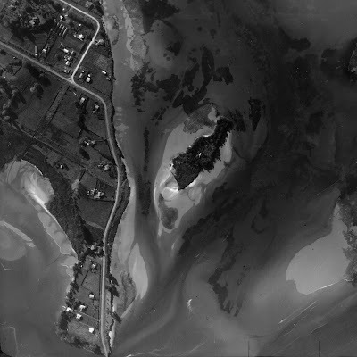
In more recent times it has been the home to at least two European occupants, Charles Spearing Kensington from the early 20th Century until about 1928 and later William O’Halloran and his wife Ethel from the early 1930s for almost 30 years. There is clear evidence of a dwelling on aerial images from 1937, 1943 and 1959.

1937 Aerial shot of Motuopuhi clearly showing the roof of a dwelling
Image courtesy of Tauranga City Libraries, Pae Korokī, Ref. 99-448

According to Max Avery in his book Maritime Tauranga, Charles Kensington was "an early Tauranga surveyor born in Bath, England, who came to New Zealand aged four, engaged in survey work in various parts of New Zealand and later in timber milling in the Coromandel be-fore settling at Oropi. He was a Crown lands ranger, his district extend-ing from Coromandel to the East Cape, and he retired from that position in 1917 to Ohauiti, dying in 1930."

Former farmer and horse trainer William O’Halloran  and his wife Ethel took up residence and they kept a Model T car in a shed on Turret Rd opposite his island home. I assume they lived without power in the manner of pioneers of earlier times.  (To be continued as new information has just come to hand.)

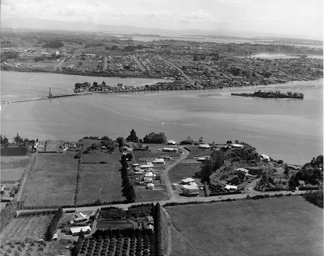
Aerial View of  Maungatapu Rd, Anchorage Grove looking over the Waimapu Estuary. Harini  Bridge is centre. c 1960 Carters Photo Services
Image courtesy of Tauranga City Libraries, Pae Korokī, Ref. 00-152

When the writer was young her class was taken to Rat Island by a Standard 4 teacher for an estuary study and also many times on family outings for swimming and picnicking. These days she takes her grand-children there for adventures with deep black mud in the “lagoon” and to learn about the estuary ecosystem. There are still grapevines and a fig tree growing on the Maungatapu side of the island  and a surprising number of people venture there at low tide when the crossing is merely ankle deep.

NB. Apparently the name Hairini is from the Biblical Cyrene - similar to Bethlehem (Peterehema) and Judea (Huria), other local districts.

Sources
Maritime Tauranga, self published by Max Avery  2013
Pae Koroki. - THS Journal No. 14 article by E L Adams 1960
                    - Stories of Tauranga Moana, By Evelyn Stokes 1980
                    - All images courtesy of Pae Korokī
*    given verbally by a contact of Max Avery
**  In article by E L Adams