Showing posts with label Hairini. Show all posts

Friday, 11 March 2022

Motuopuhi (Rat Island) in the Waimapu Estuary

Motuopuhi. Raewyn Adams 1984
Image courtesy of Tauranga City Libraries, Pae Korokī, Ref. 99-697

This three acre, one rood, slightly raised flat island is quite close to the Turret Road Peninsula (Te Rua O Te Tuna.)* It was, according to Maori legend, formerly much closer to the pa occupied by Waitaha on the end of Maungatapu Peninsula.  The story goes that puhi (maidens of high rank) were taken there each night so as to preserve their purity and enable them to make better marriages. However after too many nocturnal trysts by young lovers the wahine of the hapu took it upon themselves to heave the island further up the estuary, thereby forming the channel along its path.

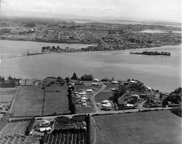
Devonport Rd and Fraser Street, looking towards Motuopuhi island with Rangataua Bay, Maungatapu and Matapihi in the back-ground c 1949, by Alfred Hugh Rendell
Image courtesy of Tauranga City Libraries, Pae Korokī, Ref. 12-592

Motuopuhi was included in land confiscated from Ngaiterangi in 1863. In 1886 H.W. Brabant reported, as Commissioner of Tauranga lands, that Hamiora Tu and Ngamanu, local chiefs, had been granted Lot 100 Te Papa Parish comprising of 52 acres “in consideration of their loyalty and of their former claims to Motu-o-puhi and the adjoining mainland known as Te Rauparanga.”  **

Evidently with an eye to its purchase, a survey of the island was begun in 1882 by Captain A.C. Turner, a licensed surveyor, but on being advised by S. Percy Smith, the Chief Surveyor at that time, that the island was Crown land, Turner did not lodge his plan. In 1913, Mr C.B. Turner, also a surveyor and a son of Captain Turner, forwarded the plan of the survey which he had found amongst his father's papers. payment was made by the Crown to the estate of Captain Turner for the survey, and the plan was lodged, examined and approved. It is now S.O. Plan 17040, and the land is now described as Section 8, Block X, Tauranga Survey District.

The island was set apart as a Reserve of Recreational Purposes in 1952 and subsequently, in 1959, it was vested in the Mayor, Councillors and Citizens of the Borough of Tauranga in trust for the same purposes. [Extract from THS Journal No 14, 1960, Courtesy of Tauranga City Library]

In more recent times it has been the home to at least two European occupants, Charles Spearing Kensington from the early 20th Century until about 1928 and later William O’Halloran and his wife Ethel from the early 1930s for almost 30 years. There is clear evidence of a dwelling on aerial images from 1937, 1943 and 1959.

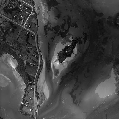
1937 Aerial shot of Motuopuhi clearly showing the roof of a dwelling
Image courtesy of Tauranga City Libraries, Pae Korokī, Ref. 99-448

According to Max Avery in his book Maritime Tauranga, Charles Kensington was "an early Tauranga surveyor born in Bath, England, who came to New Zealand aged four, engaged in survey work in various parts of New Zealand and later in timber milling in the Coromandel be-fore settling at Oropi. He was a Crown lands ranger, his district extend-ing from Coromandel to the East Cape, and he retired from that position in 1917 to Ohauiti, dying in 1930."

Former farmer and horse trainer William O’Halloran  and his wife Ethel took up residence and they kept a Model T car in a shed on Turret Rd opposite his island home. I assume they lived without power in the manner of pioneers of earlier times.  (To be continued as new information has just come to hand.)

Aerial View of  Maungatapu Rd, Anchorage Grove looking over the Waimapu Estuary. Harini  Bridge is centre. c 1960 Carters Photo Services
Image courtesy of Tauranga City Libraries, Pae Korokī, Ref. 00-152

When the writer was young her class was taken to Rat Island by a Standard 4 teacher for an estuary study and also many times on family outings for swimming and picnicking. These days she takes her grand-children there for adventures with deep black mud in the “lagoon” and to learn about the estuary ecosystem. There are still grapevines and a fig tree growing on the Maungatapu side of the island  and a surprising number of people venture there at low tide when the crossing is merely ankle deep.

NB. Apparently the name Hairini is from the Biblical Cyrene - similar to Bethlehem (Peterehema) and Judea (Huria), other local districts.

Sources
Maritime Tauranga, self published by Max Avery  2013
Pae Koroki. - THS Journal No. 14 article by E L Adams 1960
                    - Stories of Tauranga Moana, By Evelyn Stokes 1980
                    - All images courtesy of Pae Korokī
*    given verbally by a contact of Max Avery
**  In article by E L Adams

Friday, 16 April 2021

Recent ANZAC Tradition in Tauranga Moana

Flagpoles, Tutereinga Marae

In April 1995, Howie Wilson says, he and three of his mates found the Anzac Day crowds at the Mount Maunganui RSA too large for their liking. The press of people in the club did not allow for the quiet reflection and exchange of memories that marked the day for him and Lincoln Smith, Perry Smith, and Tapuraka Dickson, all veterans of New Zealand’s campaigns in Malaya, Borneo and Viet Nam. They took themselves off, with a couple of crates of beer, to a retreat within sight of Hairini marae.[1] (This was not a new thing - old soldiers had made it their informal catch-up place as early as the 1980s.)

Marae are places of connection and re-connection, places imbued with meaning. It is not, therefore, surprising that the idea that came to Howie and his former brothers-in-arms on Anzac Day 1995 brought together past and future commemorations and began a new tradition. Five years later, after much korero and organisation, Ngāti Tapu hosted a dawn ceremony at Waikari marae on the Matapihi peninsula.

Howie and Donna planning, Tutereinga Marae

The first Parade Commander was a retired former Regimental Sergeant Major of the Hauraki Battalion, WO Ist Class Ben Morunga. The Hauraki Battalion has proved to be staunch in its support ever since, an acknowledgement of the large proportion of Maori who served in the three South East Asia campaigns. All of the veterans mentioned, except for Howie himself, have now passed on.

This was to be the first in a nineteen-year sequence, interrupted in 2020 when Covid-19 restrictions prevented any but the tiniest of Anzac gatherings.[2] The original plan was to hold the service at Hungahungatoroa, but a tangi intervened and the planning pivoted to nearby Waikari, “which was better, really,” says Howie. “The mist was well down and the contingent just came up out of it.” He was surprised and gratified at the turnout – about 500 people attended, many of them young.

Other marae were not slow to put in their bids as hosts. Over the years, dawn services have been held at nearly every marae in Tauranga Moana, including Hairini of course (in 2019) and Opureroa on Matakana Island. Given that there are 22 of them by my count [3], it was quite some time before Te Puna’s turn came.

This was to have been in 2020, the Covid year. Pirirakau elders were to be sadly disappointed; even sadder, two of the most forceful bidders, Maria Ngatai and Kiritoha Tangitu, had passed away before they could see their home marae, Tutereinga, be the venue for the service.


 “I did form the Tauranga Moana Tumutauenga Returned Services Association Inc [4],”  Howie told me.  “But I never really needed it. The service stays the same each year – only the people change.”  As the ranks of the original 38 members of the society – many of whom had served in the South-east Asian conflicts – dwindled, Howie found Tania Smith standing alongside him. She took on the takohanga in memory of her own dad, Lincoln. And the crowds, especially the presence of young people, got bigger every year.

Tania held the promise to Pirirakau as Covid restrictions relaxed. At the end of March 2021, a small group of planners got their marching orders: the wreath-making, the breakfast menu, the site of the rum station (just outside the marae), the lighting – Howie does not want anything too bright – the Ratana band and the Parade Marshall. Tania wistfully wonders if the kura choir might be coached in time to sing Hikoi kia toa, “but ke te pai if not ...” and the after-party venue (the Te Puna Rugby Club) is sorted. Photos of tipuna for the order of service, and their placement and presentation on the porch of the wharenui, no detail too small:  this will be a big day for Te Puna and Pirirakau are on their mettle.  “Expect the wharekai to  be full,” Tania tells Pirirakau whaea Donna Bidois.

“It’s an honour and a privilege,” Donna responds.

“Each marae has its own wairua,” Howie concludes. The old soldier stands in contemplation in front of the wharenui, flanked by Pirirakau whanau. Suddenly the connections are everywhere – those who are to be remembered, those who are yet to come. Marae are not monuments or memorials, but their power to contain time and memory, for “learned discourse, customary oratory, laughter, nostalgia and sharing sorrow and tears” [5] as the Ngai Te Ahi Trust describes Hairini, means it is no surprise that his idea of aligning military Anzac traditions with Maori tikanga has taken root and flourishes.

References

[1] For a useful description of this marae from interviews with twelve members of the Ngai Te Ahi hapū,  see Teddy, Nikora and Bernard, MAI Rreview, 2008, 1 Article 3; https://www.researchgate.net/publication/33051444_Place_attachment_of_Ngai_Te_Ahi_to_Hairini_Marae
[2] For instance, a few locals waited for dawn outside the near-completed Te Puna Memorial Hall, maintaining social distance.  Elsewhere, people followed public health messages and stood at the end of their driveways at 6 am.
[3] https://maorimaps.com/node/14479
[4] Records of the society, now dissolved, can be found at https://is-register.companiesoffice.govt.nz/
[5] https://www.ngaiteahi.co.nz/rohe/hairini-marae/

Friday, 9 April 2021

Brain Behind the Boats and the Bridges

Joseph Denham Brain
Loose print from Album (BWH2004-0958), Brain-Watkins House Collection

In 1844 Joseph Denham Brain was born into a family of shipwrights on the Isle of Wight. He sailed to New Zealand, married Kate, sister of Auckland shipwright William Bishop, and came to Tauranga in 1881, taking over the shipyard of Mr Charles Wood on the northern end of the Strand. He constructed not only his own home but that of his eldest daughter Ada and built for himself three coastal boats, the Ventnor, Vectus and Dream. He also owned two whaleboats, the Esther and Tarawera. The General Gordon was another boat built by this man.

Brain's boatyard, c1900
Tauranga City Library Collection. Ref. 99-751

A quick read of Papers Past could lead one to believe that he was actually more of a bridge and wharf builder. In the BOP Times he was recorded as the contractor for at least 6 bridges: the Waetou and Atuaroa No.1 bridges on the Te Puke road, the Tarawera Bridge on the Rotorua-Te Teko route, the Waitekohe Bridge near Katikati (1882), the Kopurerua Bridge in Judea (1886) and the Wairoa Bridge at Bethlehem (1892). He tendered unsuccessfully for a couple more bridges and even tried to win the contract to construct the first bathing enclosure off Tunks Point (First Ave) in 1885. He later built the Ruahihi Bridge, the Hairini Bridge (1897) and the Omanawa Bridge (1906). He certainly knew how to build the much needed bridges for this district.

Bridge in Kaimai area built by Joseph Brain, c1900
Tauranga City Library Collection. Ref. 02-064

It is also recorded that he was responsible for the concrete seawall on the Strand and the Horseshoe Wharf at Mount Maunganui in 1913, as part of the East Coast rail project. Other structures he was responsible for were Tauranga’s first fire station and bell tower in Durham Street in 1911, a 250 ft tramway on Motiti Island for loading cattle, and his last, the Memorial Gates opposite the present courthouse in 1921, only 3 years prior to his death at 80.

The years shortly after his arrival in Tauranga must have been tough as he applied to have his section, Lot 147, assessed at a lower valuation in 1881 and asked for the annual rent for his portion of the foreshore to be reduced from 3 pounds to 5 shillings. He certainly did his civic duty, serving on the school board (1891), the Borough Council (1893), the Mount Domain Board (1894) and was nominated for the mayoralty in 1895. Brain was integral part of this town’s growth, a successful and much respected man, passing away in 1924 leaving an estate of seven thousand pounds.   

Sources
Papers Past — BOP Times 1881-1924
Historical Review  May 2003
Pae Koroki

Friday, 15 January 2021

Bridges of Tauranga Borough, 1950s

From a contributer who wishes to remain anonymous.

These are my memories of life in Tauranga in the 1950s. It is amazing to think that of the 7 bridges we cross without a second thought in 2020, a mere 70 years ago 3 of them did not exist, 2 were single lane and both the rail bridges could be death traps. 

Matapihi rail bridge, Tauranga, under construction
Photograph by R.W. Meers, April 1917
Image courtesy of Tauranga City Libraries/Pae Korokī, Ref. 02-059

Matapihi Railbridge was a train bridge only but was used quite extensively by Matapihi residents. There was no walkway, resulting in over 20 people losing their lives before the pedestrian walkway was added later.

Aerial view of Matapihi and Maungatapu, showing the beginning of the causeway bridge
Photograph by Astra Publicity, March 1958
Image courtesy of Tauranga City Libraries/Pae Korokī, Ref. 01-340

There was no bridge at Maungatapu so to get to the Mount it was necessary to drive 17 miles around through Welcome Bay and Kairua Road.

Hairini Bridge under construction
Photograph by R.J. Rendell, 1920s
Image courtesy of Tauranga City Libraries/Pae Korokī, Ref. 02-121

The old Hairini bridge (built in the 1920s accessed from 14th Ave and Turrett Road) was one lane with a raised passing bay in the centre. This was to allow access to the Waimapu river traffic from earlier times.

Wairoa river bridge, with cart and horse-drawn carriage
Photograph by R.W. Meers, c1909
Image courtesy of Tauranga City Libraries/Pae Korokī, Ref. 02-050

The Wairoa River was crossed by a single lane concrete bridge. When there was a group of us needing to cross to get to our senior Pony Club instructor’s farm, she would come to meet us and ensure that the traffic from the North did not try to cross and frighten the horses.

Kopurererua Stream, Tauranga
Photograph by Fred Bicker, c1920
Image courtesy of Tauranga City Libraries/Pae Korokī, Ref. 02-356

The small bridge over the Kopu Canal is in the same position but the stream itself was realigned in the early 40s as illustrated above.

Aerial view of Ōtūmoetai showing the new Chapel Street causeway and bridge
Photograph by Bay of Plenty Times, c1960
Image courtesy of Tauranga City Libraries/Pae Korokī, Ref. 99-1399

Chapel Street ‘causeway’ bridge did not exist so all cars had to travel to and from Otumoetai via Waihi Rd. Prior to it’s construction, in 1959, pedestrians and cyclists used the adjacent railway bridge but one had to be very careful that the bicycle wheels did not get caught in the gaps of the plank decking. Of course all the locomotives were big steam-belching and smoking monsters and rather scary.

There was no Harbour Bridge but a good passenger ferry service connected with 3 wharves on the Mount side, Aerodrome Wharf, Salisbury Wharf and the stone jetty at the base of the Mount.