 |
| Motuopuhi. Raewyn Adams 1984 Image courtesy of Tauranga City Libraries, Pae Korokī, Ref. 99-697 |
This three acre, one rood, slightly raised flat island is quite close to the Turret Road Peninsula (Te Rua O Te Tuna.)* It was, according to Maori legend, formerly much closer to the pa occupied by Waitaha on the end of Maungatapu Peninsula. The story goes that puhi (maidens of high rank) were taken there each night so as to preserve their purity and enable them to make better marriages. However after too many nocturnal trysts by young lovers the wahine of the hapu took it upon themselves to heave the island further up the estuary, thereby forming the channel along its path.
 |
| Devonport Rd and Fraser Street, looking towards Motuopuhi island with
Rangataua Bay, Maungatapu and Matapihi in the back-ground c 1949, by Alfred
Hugh Rendell Image courtesy of Tauranga City Libraries, Pae Korokī, Ref. 12-592 |
Motuopuhi was included in land confiscated from Ngaiterangi in 1863. In 1886 H.W. Brabant reported, as Commissioner of Tauranga lands, that Hamiora Tu and Ngamanu, local chiefs, had been granted Lot 100 Te Papa Parish comprising of 52 acres “in consideration of their loyalty and of their former claims to Motu-o-puhi and the adjoining mainland known as Te Rauparanga.” **
Evidently with an eye to its purchase, a survey of the island was begun in 1882 by Captain A.C. Turner, a licensed surveyor, but on being advised by S. Percy Smith, the Chief Surveyor at that time, that the island was Crown land, Turner did not lodge his plan. In 1913, Mr C.B. Turner, also a surveyor and a son of Captain Turner, forwarded the plan of the survey which he had found amongst his father's papers. payment was made by the Crown to the estate of Captain Turner for the survey, and the plan was lodged, examined and approved. It is now S.O. Plan 17040, and the land is now described as Section 8, Block X, Tauranga Survey District.
The island was set apart as a Reserve of Recreational Purposes in 1952 and subsequently, in 1959, it was vested in the Mayor, Councillors and Citizens of the Borough of Tauranga in trust for the same purposes. [Extract from THS Journal No 14, 1960, Courtesy of Tauranga City Library]
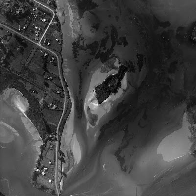
In more recent times it has been the home to at least two European occupants, Charles Spearing Kensington from the early 20th Century until about 1928 and later William O’Halloran and his wife Ethel from the early 1930s for almost 30 years. There is clear evidence of a dwelling on aerial images from 1937, 1943 and 1959.
 |
| 1937 Aerial shot of Motuopuhi clearly showing the roof of a dwelling Image courtesy of Tauranga City Libraries, Pae Korokī, Ref. 99-448 |
According to Max Avery in his book Maritime Tauranga, Charles Kensington was "an early Tauranga surveyor born in Bath, England, who came to New Zealand aged four, engaged in survey work in various parts of New Zealand and later in timber milling in the Coromandel be-fore settling at Oropi. He was a Crown lands ranger, his district extend-ing from Coromandel to the East Cape, and he retired from that position in 1917 to Ohauiti, dying in 1930."
Former farmer and horse trainer William O’Halloran and his wife Ethel took up residence and they kept a Model T car in a shed on Turret Rd opposite his island home. I assume they lived without power in the manner of pioneers of earlier times. (To be continued as new information has just come to hand.)
 |
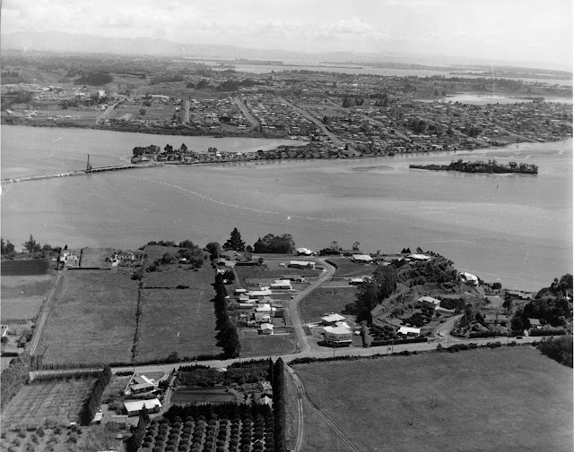
| Aerial View of Maungatapu Rd, Anchorage Grove looking over the Waimapu
Estuary. Harini Bridge is centre. c 1960 Carters Photo Services Image courtesy of Tauranga City Libraries, Pae Korokī, Ref. 00-152 |
When the writer was young her class was taken to Rat Island by a Standard 4 teacher for an estuary study and also many times on family outings for swimming and picnicking. These days she takes her grand-children there for adventures with deep black mud in the “lagoon” and to learn about the estuary ecosystem. There are still grapevines and a fig tree growing on the Maungatapu side of the island and a surprising number of people venture there at low tide when the crossing is merely ankle deep.
NB. Apparently the name Hairini is from the Biblical Cyrene - similar to Bethlehem (Peterehema) and Judea (Huria), other local districts.
Sources
Maritime Tauranga, self published by Max Avery 2013
Pae Koroki. - THS Journal No. 14 article by E L Adams 1960
- Stories of Tauranga Moana, By Evelyn Stokes 1980
- All images courtesy of Pae Korokī
* given verbally by a contact of Max Avery
** In article by E L Adams
No comments:
Post a Comment