Showing posts with label Sulphur Point. Show all posts

Friday, 21 July 2023

Shapeshifter: Our Landscape and the Te Puna Quarry

Te Puna 1954

When David and Shirley Sparks came to start farming in Te Puna the year after this 1954 photograph [1] was taken, the Quarry that lay on the hill to the south-east of their farm was a merely noticeable, rather than a noteworthy, feature. The metalled road that snaked up to it was little different in surface quality to any of the roads in the vicinity – their pale dustiness stands out in this image. Te Puna Road runs up the middle, Borell Road is off at centre right, even a pale streak of Te Puna Station Road is discernible at upper left. The rhyolite used to make and maintain them came from the Tauranga County’s quarry, at that time run by the Smythe quarrying company. The Quarry, in this picture just a background smudge on the dark Minden ridge at top right, had by that stage been a source of roading stone since 1911.

And that, it seemed, was all it would ever be. Rhyolite is not commended by most roading engineers – it is highly crystalline and degrades quickly in comparison to andesite, often called ‘blue chip’ and familiar to all of us who drive on tar-sealed roads. It is what Brian Robbins, who took over the Quarry from the Smythes in the mid-fifties, described as a “woolly” rock [2], good for the first course at the base of a roadway, and for creating a quick slurry in preparation for a firmer, harder-wearing surface, and not much else. But it was handy, and it was cheap.

By 1975,  however, this local source of rock had become a landmark that could be used as a navigational aid from well out to sea around Tauranga Moana. Here’s a closer shot [3], taken from the (now sealed) intersection of Quarry Road and State Highway 2.

Te Puna 1975

While some of the pastoral landscape typical of early twentieth-century Te Puna remains upland, and new kiwifruit and citrus orchards are coming to occupy the flats, the Quarry itself now looms as an industrial behemoth over this benign countryside. What were the reasons for this extraordinary expansion of rock mining activity on the Minden?

The answer has to do with both navigation and Depression-era forestry.  As economies recovered from World War II, new stirrings of ambition for the development of shipping, and the export of logs from mature radiata forests in and out of the Pilot Bay wharves at Mount Maunganui came to the fore [4].  (It seems odd, now, to see that the immediately alternative contender for a major port in the Bay of Plenty was Whakatane [5]. This is not the place to discuss the debate that ensued.) Outcomes, however, were to be seen in a range of 1960s reclamation projects that extended all around the Tauranga Harbour edge and, eventually, out into its depths [6] - and (as a sidenote) even contemplated eliminating the Waikareao estuary entirely [7].

Waikareao Estuary reclamation proposal

The image is of a print block, showing (in reverse) a map of the planned project, which did not proceed beyond the proposal stage. It illustrates, however, the scale of thinking that exponentially increased demand for exactly the sort of rock that came from the Te Puna Quarry.

Here’s where some of it went [8].

Strand reclamation

Anyone familiar with the present Quarry Park will recognise the useful lumpiness of rocks that settle and lean into each other, creating an inelegant but useful mass that could cope with the sea swirling through below and the pressure of cars parking above. The Strand reclamation was finished in time for two royal visits over 1962 and 1963 [9], glamorous occasions for a workaday material.

Most of the Quarry rock went into the water. Huge quantities were required for port development.  Trucks rolled out for twenty years, making a new shoreline beyond the Mission House. This 1969 image [10] shows the start of the Sulphur Point causeway, not for a harbour bridge but another purpose entrely.

Sulphur Point causeway

The causeway was part of the maritime enterprise that became the Port of Tauranga.

Training wall heading north

The astonishing “training wall” [11] in the middle of the water was designed by hydrological engineers in London, working with a tank that modelled Tauranga Moana’s tidal flows. It was the flows that were being “trained”. The line of rhyolite boulders intercepted the moving sand and built it up in sufficient quantities to enable, eventually, the advent of container cranes and a new wall of stacked containers. 

This phase of port work was completed by 1976 and the Quarry operations ceased. Here’s what it, and Te Puna, looked like in 1982[12]:

Te Puna 1982

My mother Shirley’s caption to this photograph reads: “The Te Puna Quarry showing signs of weed re-growth during … years of closure. Land development for subdivision of the Sparks farm in the foreground.” In truth, the actual foreground is occupied by clumps of Quarry rocks, features for a new garden my mother was making, in existence still.

In 1997 Shirley created, from Council records, a hand-drawn map (she chose to orient it to the south) of the effects of other subdivisions. Forty years after she came to live underneath the Minden, and twenty years after Don Thwaites’ 1975 photograph, the area shows a close-packed jigsaw of lifestyle blocks.

Shirley’s map 1997

From the hills to the sea. Quarry rhyolite underlies an emphatic story of rapid infrastructural growth and development in Tauranga Moana. The one constant is the Quarry reserve’s shape and extent [13], which has remained unchanged ever since it was gazetted in 1912. The same cannot be said of the landscape around it.

section of SO 13702

References

[2] Conversation with the author, December 2017

[3] Image courtesy of Don Thwaites, by permission

[4] Bay of Plenty Times, 23 January 1950, p.2

[5] Bay of Plenty Times, 24 January 1950, p.3

[6] A relative term.  Local wisdom described the average depth of Tauranga Harbour as “eighteen inches”.  Dredging and the hydrology of the training wall exploited harbour channels to the full.

[9] Visiting monarchs were King Bhumibol and Queen Sirikit of Thailand and Queen Elizabeth II

[11] Image courtesy of Brian Robbins.  The explanation is also his – from a conversation with the author, December 2017

[12] Image courtesy of Shirley Sparks

[13] Section of SO 13702 TePuna Eastern Grazing Run 1906 SAK33VIII, cadastral map courtesy of LINZ

Friday, 19 August 2022

Sulphur Point

Sulphur Point works, c1910-1924
Collection of Tauranga City Libraries, Pae Korok
ī Ref. 04-629

On 30 March 1885 the New Zealand Manure and Chemical Company was formed to mine sulphur on Whakaari (White Island) intending to produce both fertiliser and sulphur ore, the latter for export and also to be used in the manufacture of sulphuric acid.

The Spit and Mount, Tauranga, c1909
Postcard from the collection of Justine Neal

A base on the mainland was needed and Tauranga was chosen because of its sheltered harbour and the hilly surrounding countryside providing a convenient market for fertiliser. A site was acquired on the shore of Tauranga Harbour at what came to be known, for obvious reasons, as Sulphur Point. A small superphosphate manufacturing works was built. This plant was demolished in 1910. For the next 70 years various enterprises made use of the Spit including being used as the rubbish dump.

In 1907 George Moore established a fishing and fish drying industry at Sulphur Point and with the help of the Salvation Army a small freezing plant was set up. The Te Ope Fish Supply Company was sold to Sanford Ltd. in 1913.

The Spit and Mount, Tauranga, c1915
Chromolithographic postcard by Mirrielees & McMahon
Collection of Justine Neal

The Tauranga Defence Rifle Club had its rifle range at Sulphur Point and in 1917 Captain J.C. Millar presented to the club a handsome tea set and tray to be shot for by the ladies on the rifle range on March 1st. The lady who won it was Elva Brain and the silver tea service and tray are on display at the Brain Watkin House along with a photo of Elva beautifully attired in her long white dress and hat.

In 1923 plans were approved for the White Island Chemical Company to construct a wharf at Sulphur Point. They wanted to extend the existing jetty to a maximum of 600 feet in order that larger vessels could load and unload at the wharf at any time.

The Spit and Mauao, undated postcard
Collection of Justine Neal

In 1926 the Sulphur Point Road was metalled to give easier access to the White Island Agricultural Chemical Company’s works. This company became White Island Products and eventually went into liquidation in 1934 with the plant being auctioned on site at Sulphur Point.

In 1942 a permit was issued to the firm of J Kaaklund Ltd. for the establishment of a fish canning works. The build was not smooth sailing as the following report from the Bay of Plenty Times, 15 December 1942 records.


“While engaged in placing roofing iron on the building at Sulphur Point, which is to be used as a fish canning factory, yesterday afternoon Mr.J.D.Simpson, of Hairini and Mr. Gordon Decke, of First Avenue, fell twenty feet to the ground.

Mr. Simpson suffered a fractured leg and is a patient in Tauranga Hospital, his condition being satisfactory, while Mr. Decke suffered from shock.

The two men were sitting on a sheet of iron from which they had removed the nails to adjust, when the sheet slid off the roof, carrying Mr. Simpson and Mr. Decke with it.”

Later that year the Public Works Dept. advised that it had recently acquired three sections at Sulphur Point and wished to erect three tents or huts for their staff.

Railway Station on reclaimed land at Sulphur Point, undated
Postcard from Tauranga Heritage Collection, Ref. 0030/11

In 1944 there were plans afoot for Sulphur Point to become an industrial area. Tauranga Harbour Board leased four sections to TeKau Knitwear. Mr. P. Densem said thought needed to be given to the erection of buildings and layout and provision of open spaces so the board could not be blamed for creating slums later on.

The first proposal I can find for reclamation at Sulphur Point is 1937 when a proposal was made to reclaim 5 acres between the railway yards and the shore end of Sulphur Point. This proposal did not go ahead. Eventually land reclamation for Sulphur Point began in ernest in 1965 and by 1990 90 hectares of land had been reclaimed.

References

Island Volcano, W.T.Parham.

Dictionary of New Zealand Biography

Papers Past, Bay of Plenty Times, 3 Mar 1944
Papers Past, Bay of Plenty Times, 7 Feb 1917
Papers Past, Bay of Plenty Times, 15 Dec 1942
Papers Past, Bay of Plenty Times, 9 Apr 1926
Papers Past, Bay of Plenty Times, 29 Sept 1944
Papers Past, Bay of Plenty Times, 3 May 1926
Papers Past, Bay of Plenty Times, 14 Aug 1942

Friday, 1 October 2021

Laura Dunnage, photographer

On 1 July 1901 an article on page 2 of the Bay of Plenty Times announced the arrival of a Miss Dunnage who would be staying in town “for a few days.” On the next page an advertisement appeared in which she presented her credentials – Christchurch School of Art and holding South Kensington certificates – while offering tuition in drawing, painting and landscape sketching from nature. What pearls of artistic wisdom she may have imparted to the community is unknown, as no contemporary accounts of such lessons are known. However, it was a large wooden case in her luggage that she neglected to mention which afforded a much more tangible legacy to her stay in the Bay of Plenty.

Laura Constance Dunnage (1874-1957)

Who was the eminently qualified Miss Dunnage? Laura Constance Dunnage was born in 1874 in Papanui, Christchurch, the youngest of eleven children of farmer George Dunnage (1830-1904) and his wife Louisa née Bowron (1831-1905). Her schooling in West Christchurch was accompanied by the usual array of “commended” awards, as well as prizes for her hand bouquets and cut flower displays at the annual summer flower shows. As implied in her advert, she then attended the Christchurch School of Art between 1892 and 1896.

She probably came to Tauranga because one of her older brothers was Walter Henry Dunnage, a former government surveyor who had been living at Waipapa – near Aongatete – since 1895 and working on various contracts in the district and further afield.

1st Avenue, Tauranga, 1901
Photograph by Laura C. Dunnage from the Dunnage-Hartree Family Album
Courtesy of Jan Hartree & Tauranga City Library (Pae Koroki) Ref. 00-651

Laura Dunnage brought a field camera – probably half-plate – with her to Tauranga, and demonstrated that she was already quite proficient in its use by capturing a series of views of the townscape. In this image of three children amusing themselves with a pony and sled in 1st Avenue, her open camera case is seen at right in the foreground. By 1901, she would have been using the readily available dry plates, which could be safely stored in the box after exposure, and then processed when she returned home in the evening.

Tauranga Harbour, 1901
Photograph by Laura C. Dunnage from the Dunnage-Hartree Family Album
Courtesy of Jan Hartree & Tauranga City Library (Pae Koroki) Ref. 00-659

A view of the Tauranga foreshore at low tide with Mauao on the skyline is captioned, “Moonlight on the harbour,” which would have been quite an achievement although, judging from the detail visible in the dark areas of the image, it seems more likely that it was actually taken mid-morning.

Sulphur Mill, Tauranga, 1901
Photograph by Laura C. Dunnage from the Dunnage-Hartree Family Album
Courtesy of Jan Hartree & Tauranga City Library (Pae Koroki) Ref. 00-662

Her scene of the derelict sulphur works on the Spit, which later became Sulphur Point, is so atmospheric it seems almost haunting. The photographer’s companion, a young woman, waits for her in a one-horse gig, carefully positioned adjacent to a rough track in the foreground. The tall chimney and building of the former fertilizer factory are framed by Karewa Island and Mauao on the skyline, and a narrow foot jetty has been left high and dry by the receding tide.

Miss Dunnage wasn’t the first woman in the Bay of Plenty to venture into the decidedly male-dominated pursuit of photography. Emily Surtees, daughter of Katikati pioneer George Vesey Stewart, brought a camera with her when she returned from England with her husband in late 1898, and photographed family, friends, homes, social events and local scenes in the Katikati district before they returned to England in 1900. Mary Humphreys took up photography, probably soon after her husband died in May 1898, and her circumstances most likely dictated a more professional direction. A year later in May 1899, she was confident enough to photograph the Governor’s reception in Tauranga, offering prints for sale as mementoes of the event at bookseller Thomas Duncanson’s Novelty Depot next to the Commercial Hotel on The Strand. By December that year she was supplying images for publication in the Auckland Weekly News.

Scene on the Kaimai Track to Cambridge, photograph by Laura C. Dunnage, 1901
Published in Auckland Weekly News Supplement, 19 Dec 1901
Courtesy of Auckland Library Heritage Images, Ref. AWNS-19011219-3-4

Laura Dunnage remained in Tauranga for a good deal longer than the “few days” originally planned, and decided that she too might able to derive some revenue from what had hitherto been a leisurely pursuit. One might speculate that she may even have been given a nudge in that direction by Mary Humphreys. It was, after all, a small community. On 14 December she boarded the SS Clansman bound for Auckland armed with a portfolio of her scenic photographs, and presumably met with a favourable response. By the time she returned to Tauranga in late January, having spent Christmas with her family in Christchurch, her photograph of the Wairere Stream above the falls on the track across the Kaimais to the Waikato had been published under her byline in the Auckland Weekly News.

Beaching the Whaleboat, Motiti, c.1901-1903
Photograph by Laura C. Dunnage from the Dunnage-Hartree Family Album
Courtesy of Jan Hartree & Tauranga City Library (Pae Koroki) Ref. 00-671

She rented Gray’s Cottage in Willow Street, next to Hammond’s timber yard, and again advertised her services as an art teacher. A collection of oil paintings, including some by Miss Dunnage, were exhibited at the Chrysanthemum Show in April. She also demonstrated and instructed in Indian Club exercises, the 19th century equivalent of aerobics or zumba. Together with a party of friends she made an expedition to Motiti Island in the yacht Hopara, probably in December 1902, returning with at least two dozen exposed glass plates, although some may have been taken on other trips to the island. She pasted prints of these in an album that was later digitised for the Tauranga City Library, and include two which were subsequently published by the AWNS on 26 March 1903.

Large gathering at Te Hiinga-o-te-Ra wharenui, Motiti, c.1901-1903
Photograph by Laura C. Dunnage from the Dunnage-Hartree Family Album
Courtesy of Jan Hartree & Tauranga City Library (Pae Koroki) Ref. 00-669

Apart from scenes showing the visiting party in their yacht, and picnicking and bathing in Orongatea Bay, she also took pictures of local residents at Tamateakitehuatahi and Te Hinga-o-te-Ra wharenui and outside their whare.

A “bush whari,” Oropi, c.1901-1903
Photograph by Laura C. Dunnage from the Dunnage-Hartree Family Album
Courtesy of Jan Hartree & Tauranga City Library (Pae Koroki) Ref. 00-658
Also published in Auckland Weekly News Supplement, 13 Aug 1903 (link)

Her brother Walter had in May 1902 married Caroline Kensington at Holy Trinity, Tauranga, she being from a large Oropi family. Their first child was born at Tauranga in April 1903. Laura Dunnage presumably took the photo of a “bush whari” during a visit to Oropi around this time and submitted it to the AWNS shortly after leaving Tauranga on 8 July 1903.

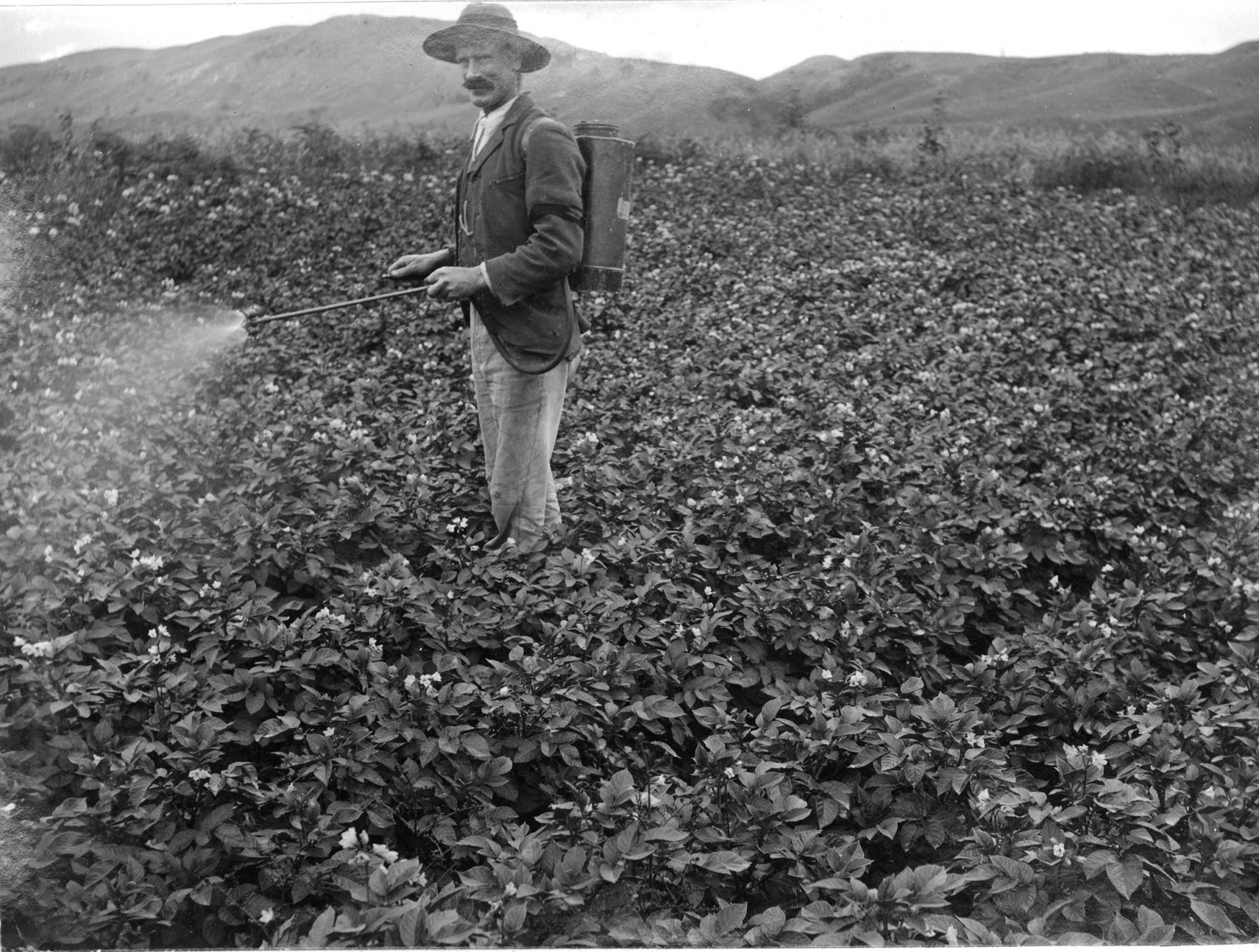
Spraying potato crop, Patoka, c.Dec 1908
Photograph by Laura C. Dunnage from the Dunnage-Hartree Family Album
Courtesy of Jan Hartree & Tauranga City Library (Pae Koroki) Ref. 00-665

After a brief stop in Gisborne she returned to live in Christchurch. Further photographs compiled in the album (1905-1906) and published in the AWNS (Sep 1910) demonstrated that she was still active with her camera. In late 1908 she produced a flurry of images of farming scenes around Patoka and Rissington, north-west of Napier. The man spraying the potato plants in the image above is probably Henry Harper Hartree (1883-1976) who she married at St Augustine’s, Napier on 3 June 1913. They had a son Harry Nelson Hartree born at Napier in 1917. It is unknown whether she continued with her photography after her marriage.

“In the track of the bush fellers, Patoka, Feb 1909”
Photograph by Laura C. Dunnage from the Dunnage-Hartree Family Album
Courtesy of Jan Hartree & Tauranga City Library (Pae Koroki) Ref. 00-711

A final image from the Dunnage-Hartree album includes a possible self portrait (at left). Laura C. Dunnage died at Napier in 1957 and is buried in Taradale Cemetery.

References

McCauley, Debbie (2020) Emily Surtees, a Snapshot of Katikati
Indian Club, Wikipedia
Heritage Images, Auckland Library
Pae Koroki, Tauranga City Library
Papers Past, Alexander Turnbull Library
Family Trees from Ancestry.com