Saturday, 14 May 2022

Photographing the Queen: the 1963 Royal visit (Part 1)

Royal Yacht Britannia in Waikorire (Pilot Bay), Mt Maunganui, 9 Feb 1963
Bay of Plenty Times, 120 (medium)-format film negative
Tauranga City Libraries, Gifford-Cross Collection, Pae Korok
ī Ref. gca-4724

When the Royal Yacht Britannia with Queen Elizabeth and Prince Philip on board steamed through the Tauranga Harbour entrance on the morning of 9 February 1963, you might have been forgiven for thinking that the entire population of Mount Maunganui and Tauranga had turned out to see them. Pilot Bay was packed with every kind of craft imaginable, and photographers from the local, regional and international press planned to capture the event from every angle, including the air.

Prince Philip and the Queen on board RMS Britannia, Mt Maunganui, 9 Feb 1963
Bay of Plenty Times, 35mm format film negative
Tauranga City Libraries, Gifford-Cross Collection, Pae Korok
ī Ref. gcc-1619

It was not the first Royal Visit to New Zealand. The earliest had been by Prince Alfred, Duke of Edinburgh in 1869 and 1870, including a visit to Tauranga on 13 December 1870. The Queen was the first reigning monarch to visit, touring the country with her husband in the summer of 1953-54, with New Zealanders going to extraordinary extents to present themselves in the best manner possible. Sheep were dyed red, white and blue, unsightly buildings hidden by screens, roads sealed in haste, and it is estimated that three out of every four New Zealanders saw the Queen at more than 110 functions in 46 different centres over almost six weeks.

New Zealand Royal Visit 1963 Itinerary
Collection of Archives New Zealand, Ref. AEFZ 22624 W5727 2618 3105/0068-0070

In 1963 the itinerary was trimmed substantially, with Mt Maunganui-Tauranga the third of eight stops over a mere 11 days.

Press photographer, Mayor David Mitchell, Prince Philip and the Queen at Coronation Pier, 9 Feb 1963
Still from 16mm movie footage by Norman Blackie, “Coloured Fountain & Royal Visit – 1963”
Collection of Nga Taonga Sound and Vision
Digitised for Tauranga City Libraries, Pae Korok
ī

After being delivered to the wharf off Tauranga’s Strand by motor launch, the Royal couple were taken on a ceremonial drive through the streets to Memorial Park, where a public welcome from a crowd of 5000 was led by the Mayor and other dignitaries in the Soundshell. “Twelve ballet girls dressed as Greek maidens danced in front of the Queen scattering pink and white rose petals from shallow baskets.”

A press photographer is seen in the still above taken from amateur movie footage. He wields two medium-format TLR cameras, including a professional Mamiyaflex C2 with eye-level finder, and may have been responsible for some of the Bay of Plenty Times footage from that day that survives in the Tauranga Library’s collection.

Press photographers wait for the Royal Party – the Queen and Mayor Mitchell at Memorial Park
Detail from Bay of Plenty Times, 120- and 35mm format film negatives
Tauranga City Libraries, Gifford-Cross Collection, Pae Korok
ī Refs. gca-4688, gcc-1632

The press photographers were waiting for them at each step of the procession, including this film cameraman from ATN’s Channel 7. The Queen and Duke proceeded to the Domain before transferring to an open military Land Rover to “drive through ranks of 20,000 assembled school children.”

Photographers scramble to catch the Queen arriving at Ocean Beach, Mt Maunganui, 9 Feb 1963
Bay of Plenty Times, 35mm format film negative
Tauranga City Libraries, Gifford-Cross Collection, Pae Korok
ī Ref. gcc-1606

The limousine then took them back through the crowds to the wharf, and they were transferred across to the Mount to watch a surf carnival from a temporary grandstand at Ocean Beach.

Mt Maunganui Mayor Harris with the Queen and Duke, Salisbury Wharf, Mt Maunganui, 9 Feb 1963
Bay of Plenty Times, 35mm format film negative
Tauranga City Libraries, Gifford-Cross Collection, Pae Korok
ī Ref. gcc-1602

The Royal party then left for the Britannia via Salisbury Wharf, where the photographers were once again in attendance from every conceivable vantage point.

RMS Britannia leaves Tauranga Harbour, 9 Feb 1963
Bay of Plenty Times, 35mm format film negative
Tauranga City Libraries, Gifford-Cross Collection, Pae Korok
ī Ref. gcc-1618


Many of these photographs taken by Bay of Plenty Times staff have been preserved and digitized by Tauranga Library, and are available to view on their web site, Pae Korokī.

Correction. An earlier version of this article incorrectly identified a photographer as BOPT journalist Max Avery - thank you to Max for pointing out that it is not, in fact, him, and that he was fully occupied on the Mount side of the harbour during the visit. If anyone is able to identify the photographer in the third photo of this article, I would be very grateful.

Part 2 of this story will look at amateur photography during the Royal Visit.

References

Queen Elizabeth – Page 3 – Royal tours, URL: https://nzhistory.govt.nz/politics/queen-elizabeth/royal-tours, (Ministry for Culture and Heritage), updated 4-Feb-2022

New Zealand's first royal visit, URL: https://nzhistory.govt.nz/page/new-zealands-first-royal-visit, (Ministry for Culture and Heritage), updated 19-Oct-2020

The royal visit, 1953-54, URL: https://nzhistory.govt.nz/culture/royal-visit-of-1953-54, (Ministry for Culture and Heritage), updated 6-Jan-2016

Programme for Today, Press, Volume CII, Issue 30052, 9 February 1963, Page 12. URL: https://paperspast.natlib.govt.nz/newspapers/CHP19630209.2.103 (Papers Past)

Early Crowd at Wharf, Press, Volume CII, Issue 30053, 11 February 1963, Page 12. URL: https://paperspast.natlib.govt.nz/newspapers/CHP19630211.2.97

Friday, 6 May 2022

Iron over the Water

Early settlement of Tauranga Moana benefited hugely from the natural accessways of its estuaries and waterways – navigable at least to the limits of their tidal swells and occasionally, as in the case of the Waimapu, Kopureroa, Wairoa, and Uretara, quite a lot further inland.  But for the East Coast Main Trunk Railway, the harbour’s wide shallow stretches of mudflats and saltmarsh were impediments. Tauranga’s geography set a major challenge and made for a long gap in time before the railway from Waihi’s goldfields was joined up with the 1910 site of the "first sod" at Awakeri, "51 miles and 5 chains from Tauranga."[1]

Much has been made of the prodigious railway bridge at Matapihi[2] and a useful resource from the Katikati Library Archive[3] explains the extension from the Athenree end of the line as far as Apata. 

But the bits in between – the Waikaraeo estuary, the Bellevue saltmarsh, the Wairoa River, and the not unimportant watery gulfs between three Te Puna peninsulas[4] – also needed bridging.  No fewer than eight bridges of varying lengths were built as the line skirted the harbour edge from Waikaraeo before it turned inland to Apata.  Crossings were needed at the Waipapa Estuary and another minor channel west of Pahoia.  Perhaps the degree of engineering expertise required was not on the scale of the Matapihi construction but these other gaps in the landmass were just as important to fill. 

The survey for the Waihi-Tauranga line had been completed as early as 1908[5].  Its actual building came much later – and the bridges were the last and most expensive items to go in.  And, as usual, everyone wanted to get the most out of them.

Building the railway bridge over the Waikareao Estuary, Watercolour by Ethel McMillan
Collection of Tauranga City Library, Pae Korokī Ref.

This exuberant watercolour by Ethel Mcmillan[6] shows why excitement ran high as residents of Otumoetai speculated on the possibilities of a very shortened trip between their rural area and the township.  There was much talk of multi-modal transport (rail and road), "planking" the railway in between trains to allow for road vehicles, and even a Plan C (a mere footbridge) before Minister of Works J G Coates firmly scotched[7] the idea.  His successor Minister K S Williams in fact walked[8] the still-unfinished rail bridge in 1927, but it was to be another thirty-five years before cars went over the Waikaraeo rather than around it.  Boy Scouts, however, were in 1932 allowed a hike[9] that let them loop home via Judea. Trains had been running regularly on the track since 1928.

Wairoa River Bridge construction, 1925, by unidentified photographer
Collection of Tauranga City Library, Pae Korokī Ref. 03-544

The Wairoa River mouth was a significant challenge, well under way in 1925[10].    The flatland of Tahataharoa is in the mid-ground on the right of this image; beside and beyond it Pukewhanake occupies the centre; and the challenges of employing heavy infrastructure on fragile wetland, still felt today, are evident in the marshy wheelmarks on the river shore.  The rather sleek launch and the busy barges – engaged in floating the steel spans into position with the aid of the tide – seem much more at home in this watery environment than the boxy piles and their randomly-angled guardian poles.

Forfeiting the navigability of the Wairoa did not go unquestioned.  As early as 1910 one W R Turner (unrelated, as far as the writer can tell, to the County Engineer Archibald Turner) advocated for the "value of the Wairoa as a waterway.[11]  But the glamour and convenience of road transport was already beguiling both politicians and populace.  Coates pointed out, when asked for a significant Public Works loan for the ECMT line, that he had delivered substantial sums to roading "not yet served by a railway."[12]  The predictable brouhaha about the actual site of the Te Puna Station was significantly influenced by canny hopes that an "adequate" road[13] would align to the railhead for the convenience of farmers.  So it proved.  Te Puna Station Road’s logistic importance will be overcome only when the Takitimu North Link comes into operation, this century[14].

In 1924 construction of the railway between Tuapiro and Tauranga was contracted to Sir William G Armstrong, Whitworth and Company[15].  A great many dignitaries, including the British Trade Commissioner, engaged in a complicated journey from Wellington via Waihi to Athenree (motor cars from there to Te Puna) where a shirtsleeved Minister Coates, having been welcomed by Potaua Tangitu, watched a "steam navvy" cut the first substantial sod in the line on his behalf.  It was a great day for Te Puna, culminating in a grand celebration dinner that "might easily rank as the most notable function ever held in Tauranga."[16]

Omokoroa railway[17]
Collection of Western Bay Community Archives, Ref.

As for the rest?  We know the line made its way through the soft geology of the harbour basin of Tauranga Moana.  We are also fortunate to have some practical idea of how Sir William et al actually did the job. 

Railway Overbridge plan[18]
Collection of Western Bay Community Archives, Ref

Although dated 1917, it is realistic to assume that the blueprints for the Public Works Department bridges were what Whitworth & Co used to make their railway’s shorter jumps over the waterways that had previously served as transport options.  Australian hardwoods took over from sloops and barges.  The harbour that had for centuries been a highway was, from 1927, caught in a steel and imported hardwood web.


[2] J Neal, “The East Coast Railway” taurangahistorical.blogspot.com, 6 December 2019

[3] https://westernbay.recollect.co.nz/ East Coast Railways, 2012, Katikati Advertiser Collection

[4] At the end of what is now Newnham Road (the Te Puna Stream estuary).; at Plummers Point; and at Mangawhai Bay

[5] WAI215 AO50.pdf.  Anthony Fisher, Keni Piahana, Te Awanuiarangi Black, and Rahera Ohia, Issues Concerning the Use, Control and Management of Tauranga Harbour and Its Estuaries, Report Commissioned in September 1996 by the Waitangi Tribunal for the Tauranga Claim (Wai215)

Tuesday, 3 May 2022

Scribbles and scratchings (Horatio Robley in Ams 261)

From Tauranga City Library’s archives
A monthly blog about interesting items in our collection

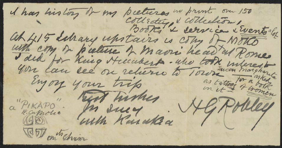
The scribbles and scratches of Pablo Picasso are worth exorbitant amounts of money, such is the universal acclaim of the man. Not quite so universally acclaimed is our own Horatio Gordon Robley (1840-1932) who has attracted both admiration and ire. The admiration is mostly for his art and in particular his interest in tā moko. His 1896 published book “Moko; or Māori Tattooing” for example preserved much of this knowledge during a time when the practice was actively suppressed by Pākehā.  But also ire, for the way we made a collection of preserved Māori heads from various shops and collectors in Europe during his retirement. A thesis by Tim Walker (Walker, 1985), of which we have a copy in our archives, has been an influential read in this space. 

Ams 261 consists of the letter fragments by Robley writing to the younger John Cuthbert Adams (1854-1932), former mayor of Tauranga (1917-1919).  Most locals will know Adams from the ‘Adams Cottage’ on Adams Ave in Mount Maunganui (Arabin, 2015). The letters to Adams are mostly scraps, typical of Robley, written on torn off letter bottoms and decorated with illustrations and doodlings. There are seven parts or series to the collection, carefully arranged by Heritage Specialist Jody Smart and now stored in the library archive climate-controlled room.   

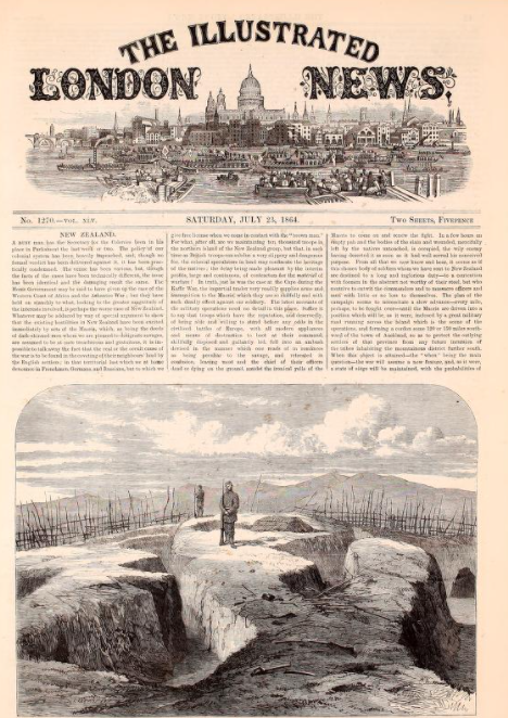
Series one mentions (among other interesting things) his hasty sketching of trenches after the Battle at Pukehinahina (1864) to send them on their way to The Illustrated London News, where they are published on July 23. Robley had arrived in New Zealand as part of the 68th Durham Regiment of Foot Light Infantry, tasked with securing it as part of the colonial invasion of the Waikato and Bay of Plenty. His art, undertaken during the actual conflict and immediately afterwards, is considered a contributing factor to the public discontent with the war back in England (Simons, 2019). An etching published in The Illustrated London News, and based on his sketch, sits alongside a scathing rebuke of the war declaring the “real cause of the war is the coveting of their neighbours land by English settlers” so that the “colonial speculators in land may confiscate the heritage of the native(The Illustrated London News, 1864)

The Illustrated London News. (1864, July 23).

It’s interesting to note some of the differences between this etching based on Robley's work, and his own watercolour (below). The etching back in London has been interpreted to a degree. There is no dead or dying Toa in the etching and no British carrying away the dead in the background. The watercolour seems to show an understanding of the functions of the pa construction too. It depicts dugouts coming off of the trenches, which played a crucial role in protecting the defenders as they waited to spring the trap. The etching shows no such awareness. 

In series two, Robley refers to an event just before the Battle at Pukehinahina, in which he had found time to go duck-shooting up the Waimapu estuary with his guide, Raniera Te Hiahia. Never without a sketchpad, he’d sketched the inland view to the south-west and put it away. Later during the early part of the battle, when he saw from a frontal position, Māori entrenching on Pukehinahina, he knew he was viewing from another angle one of the ridges drawn in the sketch (Melvin, 1957, page 9). This is a time in British military history when there simply wasn’t a great emphasis on surveillance or intelligence gathering (Simons, 2019) so it is astounding that the British were able to flank the Māori at Pukehinahina simply because of the accidental intelligence gathered during someone’s recreation.  To finish that account, Robley had been taken by Colonel Greer to see General Cameron, who was then able to place troops in the rear of the Māori position before opening his attack. In this part of series two, Robley recalls how the firing created artistic reflections on the wet ponds and pools, which made for a nice picture.


Series three is a 1929 letter to Robley from an old soldier friend in the 68th and serving in Egypt. Robley has used the reverse to write to J.C. Adams, recalling how he ran to catch the coast steamer on April 30 to send sketches to the Illustrated London News and to inform family of his whereabouts.

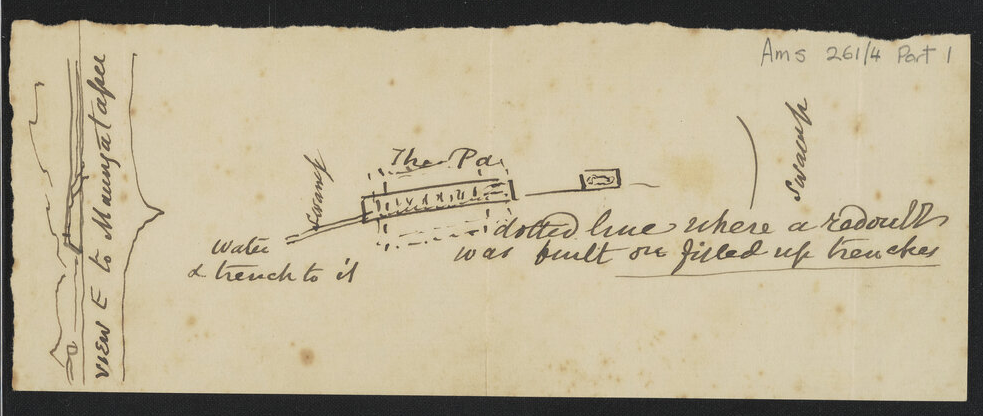
Series four contains a sketch looking westward toward the battle site Pa at Pukehinahina (at the top of this article). On the reverse is the view from the other side.

Series five includes a small newspaper cutting discussing the gifting of a photo of the pātaka of Tame Te Kapua to the Premier by Mr D. Asher and a letter referencing the work of Tregear, Edward (1846-1931), a prolific writer of the time. In 1891 Tregear published the Māori-Polynesian Comparative Dictionary.

Series six includes Gilbert Mair's notes on a Robley's picture published by scholars Percy Smith and James Cowan and the final series seven refers to Robley’s painful knee and his need to go about “on sticks”.

The papers are small and inconsequential looking, but we see in the illustrations dotted throughout, the mind of an artist fascinated with Māori design and art. 

Pae Korokī is not a static thing, we need your help to keep improving it. Here, for example, we often struggle to correctly transcribe the handwriting. If you excel at reading difficult handwriting, pop into Pae Korokī and click the “TEXT” button then “Transcription” where you can read our efforts. You might be able to then “suggest an edit” using the button on the top left of the page (it looks like a pen hovering over a piece of paper).   

See also a "The Past and the Curious" video on this topic (May 4th, 2022)

Sources:

Arabin, S. (2015). Adams Cottage, Mt Maunganui. Retrieved from Tauranga Historical Society and Brain Watkins House: http://taurangahistorical.blogspot.com/2015/07/adams-cottage-mt-maunganui.html 

Melvin, L. (1957). Horatio Gordon Robley, Soldier Artist in The Bay of Plenty 1864-1866 (edited version of "Soldier with a Pencil"). Tauranga Historical Society (1990)

Engraver using Robley. (1864). The war in New Zealand - the conflict of April. Museum of New Zealand, Te Papa Tongarewa: https://collections.tepapa.govt.nz/object/224988 

Ray, W. in Radio New Zealand's podcast "Black Sheep". Headhunter, the story of Horatio Robley

Robley, H. (1864). Breach at Gate Pa, morning of April 30, 1864. Museum of New Zealand Te Papa Tongarewa. https://collections.tepapa.govt.nz/object/139061 

Simons, C. (2019). Soldiers, Scouts and Spies. Massey University Press

Tauranga City Libraries, Ams 261: https://paekoroki.tauranga.govt.nz/nodes/view/57267 

The Illustrated London News. (1864, July 23). Retrieved from Internet Archive: https://archive.org/details/illustratedlondov45lond/page/80/mode/2up 

Walker, T. (1985). Robley : Te Ropere, 1840-1930, a thesis. Auckland: Auckland University