Friday, 31 January 2025

The When and Why of Provincial Anniversaries

Provincial government boundaries came into effect on 17 January 1853. Over time the number of provinces increased to ten
Map courtesy of Te Ara, The Encyclopedia of New Zealand

Two recent work-related mix-ups around Auckland Anniversary Day got me wondering about the when and why of provincial anniversaries. A quick search online revealed their relevance is increasingly debated and calls for consolidation, or even cancellation, are frequent. One of the most persistent arguments is that regions, like Waikato, should have their own celebration. Seemingly anniversaries being determined by a system of provincial government established in 1852 and abolished in 1875 is at best antiquated, and at worst, a vestige of colonialism. [i]

William Hobson, Oil portrait by James Ingram McDonald
Courtesy of Alexander Turnbull Library, National Library of New Zealand, Te Puna Matauranga o Aotearoa

Six regions currently celebrate Auckland Anniversary - Waikato, Auckland, Coromandel, Bay of Plenty, Northland, Gisborne, and parts of Manawatū-Whanganui. The day carries the additional historical significance of being New Zealand’s first public holiday. The commemoration date of 29 January marks the arrival of William Hobson in the Bay of Islands in 1840 and was gazetted in 1842:

Saturday, the 29th instant, being the SECOND ANNIVERSARY of the establishment of the Colony, His Excellency the Governor has been pleased to direct that day to be held as a GENERAL HOLIDAY on which occasion the Public Offices will be closed.[ii]

Hobson would later state that 30 January was the day the Union Jack was hoisted up the Herald’s flagpole at Kororāreka (Russell) and British Sovereignty over New Zealand was proclaimed. As a result, there was some fluidity around the date of the anniversary. At the end of the 1800s and the turn of the 1900s, the Bay of Plenty Times regularly printed advertising which used either date.

Advertisements for the annual Athletic Sports Day held at the Tauranga Domain on Auckland Anniversary Day. Printed in the Bay of Plenty Times in the weeks before each event, they show how the two dates were considered Anniversary Days. Courtesy of Papers Past

With ‘Mondayisation’ the date we observe the holiday is different each year. Indeed, in 2027 Auckland Anniversary won’t even be in January, the Monday falling on 1 February.[iii] Not that this will be the first time it’s been held in February. In 1901 the death of Queen Victoria necessitated the postponement of the celebration.[iv]

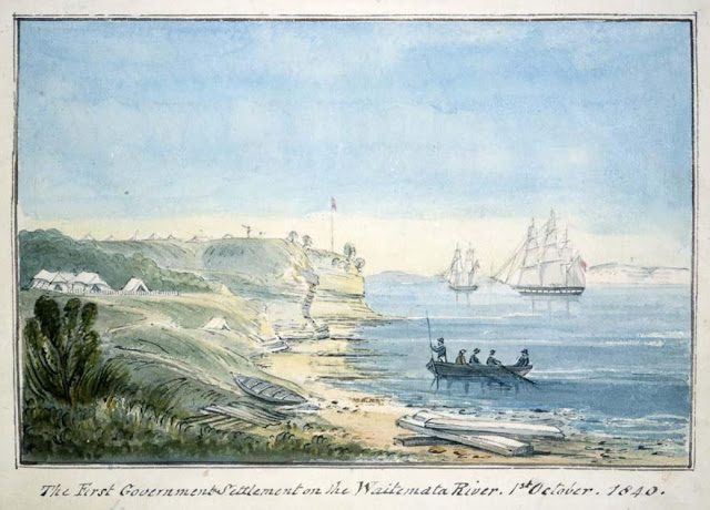
The campsite of the advance party sent to establish the newly founded city of Auckland, September 1840
Courtesy of Alexander Turnbull Library, National Library of New Zealand, Te Puna Matauranga o Aotearoa, Ref. E-216-f-115

Last year, in an additional twist to the date debate, Ngāti Whātua Ōrākei Trust called for the holiday to be moved to 18 September – the day Ngāti Whātua chief, Āpihai Te Kawau, gifted Hobson 3000 acres to establish the settlement of Auckland.[v] According to the trust this was the “true birth of the city”.[vi] While this seems a valid point for Auckland, those of us in the regions might be left wondering if it is indeed time to go our separate ways. However, it might be a case to be careful what we wish for as how can the Bay of Plenty – as diverse as it is – find a date of significance to all?


[ii] The New Zealand Government Gazette, 26 January 1842, (Volume 2, 4th edition)

[iii] For those reading this blog in the future this year’s date is 27 January 2025.

Friday, 24 January 2025

Wooden Monuments – Markers of the Past

Sometimes only trees are left to remind us of human settlement. And sometimes their absence does the same. Now that a lattice of shelter-belts characterises the landscape around Tauranga, including my home locale of Te Puna, it is difficult to picture the transformation that has taken place as a consequence of both Māori and European settlement.

Google map, screenshot of Te Puna area, Snodgrass Road in the centre

About a millennium ago, when a group of ocean-voyaging waka made landfall in the sheltered waters of Tauranga Moana, the new immigrants found a remnant population, Nga Marama, and a vista of timbered hills receding to what came to be known as the Minden dome. A tiny sample of that dense bush, the reserve at Whakamarama, can be seen as a dark irregularly-shaped patch in the bottom left-hand corner of the above Google maps image[1]. But even that is not ngahere horomata (virgin forest). It was milled for timber in the early twentieth century by the Sharplins, a rival to the Gammans’ operation in Oropi[2].

Most of Tauranga was without trees for centuries before Europeans arrived. An early survey noted its countryside as “good soil, fern and tutu”[3] and the sketch made of the harbour entrance looking south from the deck of the HMS Pandora[4] offers no indication of a fuzzy, tree-lined inland horizon. Archaeological studies tell us that the local style of agriculture was a cycle of burning, cultivation and planting, moving on when the soil ceased to be productive and returning when it had recovered.This allowed no time for aboriculture. Such timber as there was was likely dedicated to building waka and important wharenui. The most venerated tree in Te Puna, a pohutukawa growing on the ravaged slopes of Pukewhanake close to the Wairoa River, is unlikely to be very ancient, although these tolerant and adaptable trees can live for half a century or more.

Old gum tree, corner of Tangitu and Te Puna Roads, 2025
Photo by Beth Bowden

The trees we see in Te Puna, therefore, were all planted after European settlement. Many of them were indeed markers of settlement, nineteenth-century examples of exotic arrivals in waves of arboreal fashion. This Australian gum has stood at the end of Te Puna Road for possibly a century. A rapid-growing species, this specimen was already huge to my five-year-old eyes in 1958.

Phoenix palms, end of Snodgrass Road Te Puna, 2025
Photo by Beth Bowden

The rusticity of this image was chosen in deliberate contrast to the sophistication of a stand of three phoenix palms that mark the end of Snodgrass Road, an area of Te Puna that was subdivided by landowner Sandy Snodgrass between 1930 and 1950.

Sutton kauri woodlot, Wallace Road Te Puna, 2025
Photo by Beth Bowden

For years after the Snodgrass homestead itself had disappeared, the Norfolk pine that marked a shady corner of its tennis lawn stood high above the surrounding rows of casuarina and matsudana willow shelter lines: cheap, mass-produced and unbeautiful trees kept trimmed for optimal economic benefit to the orchards they protect. That pine no longer pierces the skyline of Te Puna; but just along the road, on land that once was Snodgrass’s farm, a stand of kauri marks a twentieth-century investment.

Baby grey heron, Ettrick Farm, 1960
Photo by Shirley Sparks

Snodgrass Road is a name applied to a more ancient ara – a well-used pathway between the harbourside and the Minden that surveyors marked as a convenient line for a road. At its inland end, the trees changed. Farmers like John Munro preferred sturdy macrocarpas to wind-tossed fronds. Not only did a line of conifers mark his boundary with the Harper property to the north; he planted a macrocarpa near his barn and cowshed, at the bottom of wife Mary’s beautiful garden. By the time my parents took over the property, which they named Ettrick, this tree was a vast Ent-like structure.[5] Its strength and generous shade made it the ideal site for the periodic slaughter and butchering of a farm sheep for the household’s mutton. A more innocent image was caught by my mother in 1960.

Macrocarpa planted on L T Harper’s property, Te Puna
Photo taken 1970 by Shirley Sparks

The Harper farm had its signature macrocarpa too. I think Len’s father must have planted it, on the very top of the hill that was the highest point of their farm. This tree, much loved by the Harper family and ours, succumbed to disease in 2015 or so. It was a true landmark on both State Highway 2 and the horizon of the surprisingly small pastoral area that made up the productive part of the Munro’s, Sharp’s, and then the Sparks’ family farm.

Hay harvesting, Ettrick 1967
Photo by Shirley Sparks

My father made his hay on paddocks that were flat enough to take the machinery. While he cut and wind-rowed the grass himself, using his trusty Fergusson tractor, Rex Williams’ baler was a large and unwieldy beast, and the bales once made were picked up on a truck. Gradient was the key factor in an efficient, mechanised harvest. And macrocarpas loomed over the whole operation.

Hand-drawn map of Ettrick by Shirley Sparks, 1964
Photo by Beth Bowden

The treeline boundary on the lower left marks an important, original survey line that dates from Theophilus Heal’s map of 1867[6]. Here it is again, running on the diagonal in a hand-drawn map done by my mother in 1964.

Shirley Sparks mock-planting with a tiny trowel on the new house site, Ettrick, 1967
Photo by Beth Bowden

Local memory is bound up in trees. They have a chancy existence amongst their human companions, being vulnerable to development pressures, carelessness and climate change; but, left to themselves, their lifetimes extending well beyond those of the people who planted them, they can command a quiet significance. My mother who turned 95 while this essay was being written, has planted many and many a tree, not all of which have lasted her distance.  But those that will survive her will carry her memory. The same is true for others who set their saplings at roadsides and on hilltops. Trees may indeed have a secret life – and they tell a public story too.

References


[1] For an interactive scan of the extent of the thousand-year-old Kaimai bushline, go to

https://www.google.com/maps/@-37.7041192,176.0304427,7647m/data=!3m1!1e3?entry=ttu&g_ep=EgoyMDI1MDEwNy4wIKXMDSoASAFQAw%3D%3D

[3] Map of Otumoitai West, Parish of Te Puna, Cook County, SD 420

[4] https://webarchive.nationalarchives.gov.uk/ Pacific Ocean NEW ZEALAND From Surveys in HM Ships Acheron & Pandora Captn. JL Stokes, Comndrs B Drury & GH Richards Assisted by… 1848-1855

[6]  Map of Otumoetai Block, parish of Te Puna, Cook County, SD 424

Friday, 17 January 2025

Enemy at the Gates 1820, 1828

The Intertribal Musket War’s Impact on Tauranga

A Ngāpuhi musket haka or haka peruperu

During the 1820s and 1830s, the Matua-Otūmoetai foreshore boomed and echoed ominously to the roar of haka, as besieging enemy tribesmen from several iwi leapt and stamped in frustrated fury below Otūmoetai, a previously unconquerable pā tūwatawata (palisaded fortress). During the summer months of 1820, the foreshore became the scene of one of the most famous peace-making incidents of the intertribal Musket Wars.

In that year, Tauranga was invaded by a Ngāpuhi musket taua of 600-700 warriors aboard 50 waka taua.1 The expedition was initiated by the rangatira Te Morenga, who was seeking further utu for the killing, cooking and devouring of his niece Tawaputa at Tauranga in 1806. Deploying his contingent of shock troops ahead of his force (35 toa armed with the only flintlock muskets in their possession), Te Morenga oversaw the destruction by gunfire of the Ngāi Te Rangi defenders of [Mount] Maunganui Pā, who twice charged their ranks with traditional short and long weapons of stone, bone and wood. ‘For three days the grisly aftermath of the battle [fought at Waikorire-Pilot Bay] continued as the bodies of those slain were committed to the hāngī and eaten’.2

Te Morenga and his triumphant taua next turned their attention to Otūmoetai Pā. Initially bypassing the fortress, the Ngāpuhi fleet encamped on Matakana Island for several days, before sweeping en masse one morning into the Matua inlet near the Wairoa River outlet. The toa disembarked and camped on the long-abandoned pā site of Matuaiwi, a knoll overhanging the Wairoa River, about a mile and a half from the great Otūmoetai pā. Like successive enemy taua before them, they too attempted to storm Ngāi Te Rangi’s central fortress without success.3

Te Morenga’s moko Mataora (face tattoo).
Eight years after the kidnapping of his niece and sister by convict pirates in 1806, Te Morenga sketched this image of his own moko Mataora for John Nicholas, who was friend and assistant to the leading missionary Samuel Marsden

Te Waru, Ngāi Te Rangi’s paramount chief, set out alone one day to reconnoitre the Ngāpuhi camp. Advancing carefully through the ngaio trees along the foreshore, he saw Te Morenga, who was resting in the shade, also alone and unguarded. Springing upon the Ngāpuhi, Te Waru disarmed him, bound his hands and drove his prisoner into Otūmoetai Pā. There he untied Te Morenga, restored his weapons and instructed him to treat him in the same manner. When Te Morenga drove the disarmed and bound Te Waru into the Matuaiwi encampment, he, with some difficulty, persuaded his warriors not to kill his prisoner. Invited to make peace with Ngāpuhi, an extended kōrero ensued during which Te Waru accepted the offer. Soon after, Te Morenga and Ngāpuhi fleet departed for the Bay of Islands. The peace was to last until 1831, when the tohunga Te Haramiti’s Ngāti Kuri and Ngāpuhi predatory raiders were defeated by Ngāi Te Rangi and allied iwi on Motiti Island.4

In 1828, Otamataha Pā on the Te Papa Peninsula was stormed in a night attack by a Ngāti Maru musket taua under the rangatira Te Rohu, during which most of the Ngāti Tapu inhabitants were slaughtered. Te Rohu’s waka fleet then crossed to the Otūmoetai foreshore and pā, where they met with counterfire from the now musket armed defenders. The besiegers withdrew when one of Te Rohu’s wives persuaded him that the utu he had attained from Ngāi Te Rangi during the storming of Otamataha Pā was sufficient.5

A pōwhiri or welcoming ceremony on the harbourside bench beyond the palisades of Otūmoetai Pā. The palisades proved impervious to musket and cannon fire when Tītore Tākiri of Ngāpuhi launched an amphibious artillery campaign against the Tauranga people in 1832

On 17 July 1842, Ensign Abel Best visited Otūmoetai Pa at a time when it was still subject to attacks by Te Arawa contingents from Rotorua. Impressed by its defences, he recorded:

Part of the Pa is on the sea beach and part on the top of a cliff or steep bank 40 feet high. By its position naturally strong it is rendered more secure by a strong palisade and on the land side & flanks it is further protected by a deep and wide Ditch having a Stockade on its exterior side. Moreover, the level of the exterior plain is somewhat lower than that of the Pa. Were it well defended its intricacy alone would render it formidable but at present there are not men in it to defend one fifth of its great extent. Nowhere have I seen so great a number of fine Canoes the care with which they preserve their fishing nets was also worthy of remark every net being placed on a little elevated platform and then securely thatched over.6

During the Musket Wars, the Ngāi Te Rangi hapu occupying the Otūmoetai Pā site were able to defend their fortress and drive off besieging Ngāpuhi, Ngāti Maru and Te Arawa  taua. The wars set in motion more than 40 heke or tribal migrations, but Ngāi Te Rangi were never driven from their lands. Otūmoetai Pā’s steep escarpments, defensive ditches and palisades were unassailable, the defenders too well led, provisioned and resolute.

Endnotes

1 Crosby, Ron, The Musket Wars: A History of Inter-Iwi Conflict, Reed, Auckland, 1999: 71-72.

2 Ibid: 72

3 Gifford, W.H. and H, Bradley Williams, A Centennial History of Tauranga, Capper Press Christchurch, 1976: 18.

4 Ibid: 18-19.

5 Wilson, J.A. The Story of Te Waharoa, Whitcombe and Tombs, Wellington, 1907: 17.

6 Best Able, The Journal of Ensign Best, 1837-1843, Nancy M. Taylor (ed.), R.E. Owen, Wellington, 1966: 371-372.

Illustrations

Artist unknown, ‘New Zealand war-dance’, in Grant, James, British Battles on Land and Sea, Vol. III, Casell, Petter and Gilpin, London, Paris and New York, 1880: 259.

Te Morenga, self portrait in Nicholas, John, Narrative of a Voyage to New Zealand, Performed in the Years 1814 and 1815, James Black, London, 1817: 216. Alexander Turnbull Library Ref. A-080-061

Joseph Merrett, A meeting of visitors Mounganui. Tauraga in the distance. [1843?], E-216-f-119, Alexander Turnbull Library, Wellington

Tuesday, 7 January 2025

Making hay while the sun shines

 From Tauranga City Library’s archives

A monthly blog about interesting items in our collection

Activities in January can include putting New Year resolutions into practise, summer swims, camping holidays, and haymaking - so here are a few snapshots from the archives of local farms and families haymaking and haybales.

In 1926 it was 'blazing weather' when Ethel Louisa and Charles Edward Macmillan were haymaking on their farm 'Yatton Rise', at St George's Hill, Fraser Street.

Te Ao Mārama - Tauranga City Libraries Ams 80/11/40

Ethel noted in pencil on the back of her watercolour. Fifty-six of her watercolours are viewable online in Pae Koroki, many of places around Tauranga 1920-1949.


Haymaking techniques have changed over the years - we wouldn't usually now see a stack as high as the one on Armstrongs' Te Puna farm in 1938.

Te Ao Mārama - Tauranga City Libraries Photo 01-263

The Gasson's were all wearing hats with wide brims when they were baling hay with a stationary baler on Tilby's Arawa farm, Ōtūmoetai (Matua) in the 1940s.

Te Ao Mārama - Tauranga City Libraries Photo 99-1277

In 1961 it was a team effort to unload hay bales on Matapihi Farm, this image taken by the Bay of Plenty Times, and part of our Gifford-Cross collection.

Te Ao Mārama - Tauranga City Libraries Photo 99-1277

Local farmer and chairman of the Te Puke branch of Federated Farmers, Mr T.B. (Rex) Benner, of Pongakawa was in the news on 29 November 1967 for inventing an 'ingenious' device to gather hay and mechanically toss the bales onto the trailer.  After three years development, trial and error, he had registered at the Patents Office and a firm in Morrinsville was starting manufacture. While demonstrating the prototype to the Bay of Plenty Times, he described the New Years Eve that had inspired the invention - while friends were all enjoying a New Years party, him and his wife had milked 120 cows, then were in the fields until midnight with aching backs from 'lifting up hay bales the hard way to beat the weather'.

Te Ao Mārama - Tauranga City Libraries Photo 99-1277

Not all haymaking was for farming purposes, the Bay of Plenty Grand Prix racetrack relied on haybales to stop careening cars on corners. The Mount News publishing this photograph of J. Murphy's Anglia in hay bales on 16 January 1967 - check out the spectator stand.

Te Ao Mārama - Tauranga City Libraries Photo gcc-5838

Although these are all local snapshots, they'll be familiar to people in other regions, as summer haymaking was similiar across the motu (country).